You are here: Home > Network List > PR - Puerto Rico Seismic Network (PRSN) & Puerto Rico Strong Motion Program (PRSMP) Stations List
> Station CELP Cerrilos Dam > Earthquake Result Viewer
CELP Cerrilos Dam - Earthquake Result Viewer
| Earthquake location: |
Near Coast Of Northern Chile |
| Earthquake latitude/longitude: |
-27.9/-71.5 |
| Earthquake time(UTC): |
2020/09/01 (245) 04:09:24 GMT |
| Earthquake Depth: |
10 km |
| Earthquake Magnitude: |
6.8 Mi |
| Earthquake Catalog/Contributor: |
NEIC PDE/at |
|
| Network: |
PR Puerto Rico Seismic Network (PRSN) & Puerto Rico Strong Motion Program (PRSMP) |
| Station: |
CELP Cerrilos Dam |
| Lat/Lon: |
18.07 N/66.58 W |
| Elevation: |
196 m |
|
| Distance: |
46.0 deg |
| Az: |
6.519 deg |
| Baz: |
186.063 deg |
| Ray Param: |
0.07096282 |
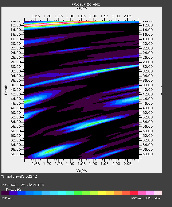
| Estimated Moho Depth: |
11.25 km |
| Estimated Crust Vp/Vs: |
1.70 |
| Assumed Crust Vp: |
5.14 km/s |
| Estimated Crust Vs: |
3.032 km/s |
| Estimated Crust Poisson's Ratio: |
0.23 |
|
| Radial Match: |
85.52242 % |
| Radial Bump: |
389 |
| Transverse Match: |
64.02993 % |
| Transverse Bump: |
400 |
| SOD ConfigId: |
21709731 |
| Insert Time: |
2020-09-15 04:22:12.915 +0000 |
| GWidth: |
2.5 |
| Max Bumps: |
400 |
| Tol: |
0.001 |
|

Signal To Noise
| Channel | StoN | STA | LTA |
| PR:CELP:00:HHZ:20200901T04:17:16.079987Z | 8.751312 | 2.4591682E-6 | 2.8100564E-7 |
| PR:CELP:00:HH1:20200901T04:17:16.079987Z | 5.257014 | 1.0038909E-6 | 1.909622E-7 |
| PR:CELP:00:HH2:20200901T04:17:16.079987Z | 1.1228441 | 1.6924257E-7 | 1.5072668E-7 |
| Arrivals |
| Ps | 1.6 SECOND |
| PpPs | 5.7 SECOND |
| PsPs/PpSs | 7.2 SECOND |


