You are here: Home > Network List > US - United States National Seismic Network Stations List
> Station LAO LASA Array, Montana, USA > Earthquake Result Viewer
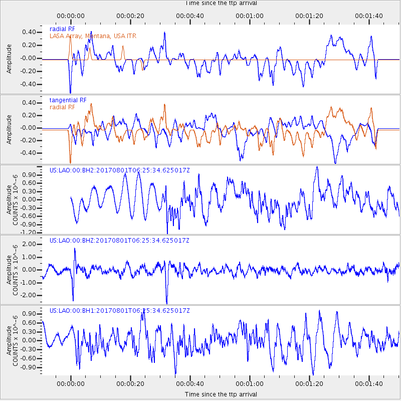
LAO LASA Array, Montana, USA - Earthquake Result Viewer
*The percent match for this event was below the threshold and hence no stack was calculated.
| Earthquake location: |
La Rioja Province, Argentina |
| Earthquake latitude/longitude: |
-28.6/-68.7 |
| Earthquake time(UTC): |
2017/08/01 (213) 06:13:53 GMT |
| Earthquake Depth: |
85 km |
| Earthquake Magnitude: |
5.6 Mww |
| Earthquake Catalog/Contributor: |
NEIC PDE/us |
|
| Network: |
US United States National Seismic Network |
| Station: |
LAO LASA Array, Montana, USA |
| Lat/Lon: |
46.69 N/106.22 W |
| Elevation: |
902 m |
|
| Distance: |
82.2 deg |
| Az: |
334.967 deg |
| Baz: |
147.268 deg |
| Ray Param: |
$rayparam |
*The percent match for this event was below the threshold and hence was not used in the summary stack. |
|
| Radial Match: |
55.39443 % |
| Radial Bump: |
400 |
| Transverse Match: |
55.936543 % |
| Transverse Bump: |
400 |
| SOD ConfigId: |
2140511 |
| Insert Time: |
2017-08-14 22:13:08.690 +0000 |
| GWidth: |
2.5 |
| Max Bumps: |
400 |
| Tol: |
0.001 |
|
Signal To Noise
| Channel | StoN | STA | LTA |
| US:LAO:00:BHZ:20170801T06:25:34.625017Z | 3.036699 | 7.148701E-7 | 2.3541025E-7 |
| US:LAO:00:BH1:20170801T06:25:34.625017Z | 1.2397257 | 4.123045E-7 | 3.3257723E-7 |
| US:LAO:00:BH2:20170801T06:25:34.625017Z | 1.110208 | 5.0016746E-7 | 4.5051686E-7 |
| Arrivals |
| Ps | |
| PpPs | |
| PsPs/PpSs | |


