You are here: Home > Network List > US - United States National Seismic Network Stations List
> Station MSO Missoula, Montana, USA > Earthquake Result Viewer
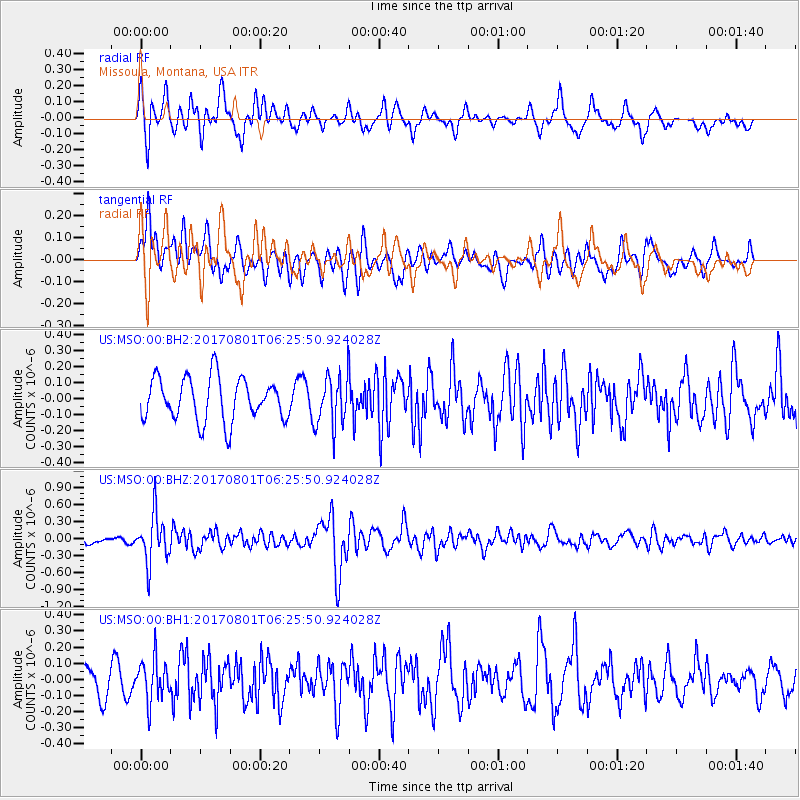
MSO Missoula, Montana, USA - Earthquake Result Viewer
*The percent match for this event was below the threshold and hence no stack was calculated.
| Earthquake location: |
La Rioja Province, Argentina |
| Earthquake latitude/longitude: |
-28.6/-68.7 |
| Earthquake time(UTC): |
2017/08/01 (213) 06:13:53 GMT |
| Earthquake Depth: |
85 km |
| Earthquake Magnitude: |
5.6 Mww |
| Earthquake Catalog/Contributor: |
NEIC PDE/us |
|
| Network: |
US United States National Seismic Network |
| Station: |
MSO Missoula, Montana, USA |
| Lat/Lon: |
46.83 N/113.94 W |
| Elevation: |
1264 m |
|
| Distance: |
85.4 deg |
| Az: |
330.722 deg |
| Baz: |
141.202 deg |
| Ray Param: |
$rayparam |
*The percent match for this event was below the threshold and hence was not used in the summary stack. |
|
| Radial Match: |
66.32001 % |
| Radial Bump: |
400 |
| Transverse Match: |
59.506783 % |
| Transverse Bump: |
400 |
| SOD ConfigId: |
2140511 |
| Insert Time: |
2017-08-14 22:13:18.752 +0000 |
| GWidth: |
2.5 |
| Max Bumps: |
400 |
| Tol: |
0.001 |
|
Signal To Noise
| Channel | StoN | STA | LTA |
| US:MSO:00:BHZ:20170801T06:25:50.924028Z | 4.4462447 | 4.2795034E-7 | 9.6249835E-8 |
| US:MSO:00:BH1:20170801T06:25:50.924028Z | 1.4777166 | 1.3053962E-7 | 8.833874E-8 |
| US:MSO:00:BH2:20170801T06:25:50.924028Z | 1.2122449 | 1.6215552E-7 | 1.3376466E-7 |
| Arrivals |
| Ps | |
| PpPs | |
| PsPs/PpSs | |


