You are here: Home > Network List > CN - Canadian National Seismograph Network Stations List
> Station ATKO Atikokan Iron Mine, ON, CA > Earthquake Result Viewer
ATKO Atikokan Iron Mine, ON, CA - Earthquake Result Viewer
| Earthquake location: |
Near Coast Of Northern Chile |
| Earthquake latitude/longitude: |
-27.9/-71.4 |
| Earthquake time(UTC): |
2020/09/01 (245) 21:09:17 GMT |
| Earthquake Depth: |
14 km |
| Earthquake Magnitude: |
6.5 mww |
| Earthquake Catalog/Contributor: |
NEIC PDE/us |
|
| Network: |
CN Canadian National Seismograph Network |
| Station: |
ATKO Atikokan Iron Mine, ON, CA |
| Lat/Lon: |
48.82 N/91.60 W |
| Elevation: |
383 m |
|
| Distance: |
78.5 deg |
| Az: |
346.53 deg |
| Baz: |
161.828 deg |
| Ray Param: |
0.0495835 |
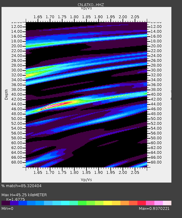
| Estimated Moho Depth: |
45.25 km |
| Estimated Crust Vp/Vs: |
1.68 |
| Assumed Crust Vp: |
6.467 km/s |
| Estimated Crust Vs: |
3.855 km/s |
| Estimated Crust Poisson's Ratio: |
0.22 |
|
| Radial Match: |
85.320404 % |
| Radial Bump: |
400 |
| Transverse Match: |
39.07388 % |
| Transverse Bump: |
400 |
| SOD ConfigId: |
21709731 |
| Insert Time: |
2020-09-15 21:13:20.212 +0000 |
| GWidth: |
2.5 |
| Max Bumps: |
400 |
| Tol: |
0.001 |
|

Signal To Noise
| Channel | StoN | STA | LTA |
| CN:ATKO: :HHZ:20200901T21:20:46.650027Z | 2.7054813 | 3.430659E-7 | 1.2680401E-7 |
| CN:ATKO: :HHN:20200901T21:20:46.650027Z | 1.7811786 | 2.1807361E-7 | 1.224322E-7 |
| CN:ATKO: :HHE:20200901T21:20:46.650027Z | 1.2973651 | 2.502894E-7 | 1.9292133E-7 |
| Arrivals |
| Ps | 4.9 SECOND |
| PpPs | 18 SECOND |
| PsPs/PpSs | 23 SECOND |


