You are here: Home > Network List > N4 - Central and EAstern US Network Stations List
> Station R49A Shelbyville, KY, USA > Earthquake Result Viewer
R49A Shelbyville, KY, USA - Earthquake Result Viewer
| Earthquake location: |
Near Coast Of Northern Chile |
| Earthquake latitude/longitude: |
-27.9/-71.4 |
| Earthquake time(UTC): |
2020/09/01 (245) 21:09:17 GMT |
| Earthquake Depth: |
14 km |
| Earthquake Magnitude: |
6.5 mww |
| Earthquake Catalog/Contributor: |
NEIC PDE/us |
|
| Network: |
N4 Central and EAstern US Network |
| Station: |
R49A Shelbyville, KY, USA |
| Lat/Lon: |
38.29 N/85.17 W |
| Elevation: |
251 m |
|
| Distance: |
67.1 deg |
| Az: |
348.264 deg |
| Baz: |
166.779 deg |
| Ray Param: |
0.05715057 |
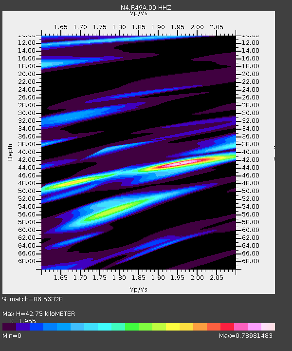
| Estimated Moho Depth: |
42.75 km |
| Estimated Crust Vp/Vs: |
1.96 |
| Assumed Crust Vp: |
6.498 km/s |
| Estimated Crust Vs: |
3.324 km/s |
| Estimated Crust Poisson's Ratio: |
0.32 |
|
| Radial Match: |
86.56328 % |
| Radial Bump: |
357 |
| Transverse Match: |
61.712494 % |
| Transverse Bump: |
400 |
| SOD ConfigId: |
21709731 |
| Insert Time: |
2020-09-15 21:19:26.811 +0000 |
| GWidth: |
2.5 |
| Max Bumps: |
400 |
| Tol: |
0.001 |
|

Signal To Noise
| Channel | StoN | STA | LTA |
| N4:R49A:00:HHZ:20200901T21:19:39.258975Z | 4.4160066 | 7.4402504E-7 | 1.6848368E-7 |
| N4:R49A:00:HH1:20200901T21:19:39.258975Z | 1.816491 | 2.4410892E-7 | 1.3438488E-7 |
| N4:R49A:00:HH2:20200901T21:19:39.258975Z | 1.3383405 | 1.2852563E-7 | 9.603358E-8 |
| Arrivals |
| Ps | 6.5 SECOND |
| PpPs | 19 SECOND |
| PsPs/PpSs | 25 SECOND |


