You are here: Home > Network List > N4 - Central and EAstern US Network Stations List
> Station S39B Bolivar, MO, USA > Earthquake Result Viewer
S39B Bolivar, MO, USA - Earthquake Result Viewer
| Earthquake location: |
Near Coast Of Northern Chile |
| Earthquake latitude/longitude: |
-27.9/-71.4 |
| Earthquake time(UTC): |
2020/09/01 (245) 21:09:17 GMT |
| Earthquake Depth: |
14 km |
| Earthquake Magnitude: |
6.5 mww |
| Earthquake Catalog/Contributor: |
NEIC PDE/us |
|
| Network: |
N4 Central and EAstern US Network |
| Station: |
S39B Bolivar, MO, USA |
| Lat/Lon: |
37.69 N/93.32 W |
| Elevation: |
340 m |
|
| Distance: |
68.4 deg |
| Az: |
341.425 deg |
| Baz: |
159.188 deg |
| Ray Param: |
0.05629307 |
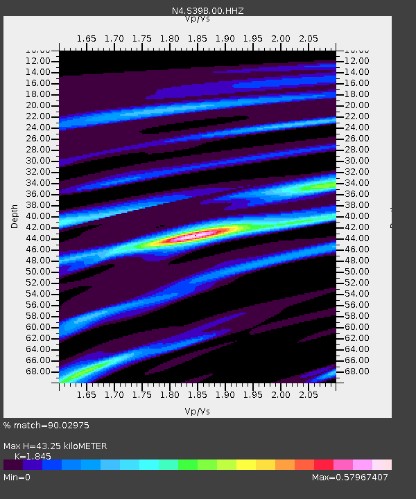
| Estimated Moho Depth: |
43.25 km |
| Estimated Crust Vp/Vs: |
1.85 |
| Assumed Crust Vp: |
6.53 km/s |
| Estimated Crust Vs: |
3.54 km/s |
| Estimated Crust Poisson's Ratio: |
0.29 |
|
| Radial Match: |
90.02975 % |
| Radial Bump: |
248 |
| Transverse Match: |
70.653175 % |
| Transverse Bump: |
400 |
| SOD ConfigId: |
21709731 |
| Insert Time: |
2020-09-15 21:19:31.679 +0000 |
| GWidth: |
2.5 |
| Max Bumps: |
400 |
| Tol: |
0.001 |
|

Signal To Noise
| Channel | StoN | STA | LTA |
| N4:S39B:00:HHZ:20200901T21:19:47.510013Z | 4.7439604 | 5.2450406E-7 | 1.1056249E-7 |
| N4:S39B:00:HH1:20200901T21:19:47.510013Z | 2.3148813 | 2.4717178E-7 | 1.06775154E-7 |
| N4:S39B:00:HH2:20200901T21:19:47.510013Z | 0.79182553 | 8.347122E-8 | 1.0541618E-7 |
| Arrivals |
| Ps | 5.8 SECOND |
| PpPs | 18 SECOND |
| PsPs/PpSs | 24 SECOND |


