You are here: Home > Network List > N4 - Central and EAstern US Network Stations List
> Station SUSD Miller, SD, USA > Earthquake Result Viewer
SUSD Miller, SD, USA - Earthquake Result Viewer
| Earthquake location: |
Near Coast Of Northern Chile |
| Earthquake latitude/longitude: |
-27.9/-71.4 |
| Earthquake time(UTC): |
2020/09/01 (245) 21:09:17 GMT |
| Earthquake Depth: |
14 km |
| Earthquake Magnitude: |
6.5 mww |
| Earthquake Catalog/Contributor: |
NEIC PDE/us |
|
| Network: |
N4 Central and EAstern US Network |
| Station: |
SUSD Miller, SD, USA |
| Lat/Lon: |
44.44 N/98.96 W |
| Elevation: |
520 m |
|
| Distance: |
76.3 deg |
| Az: |
340.054 deg |
| Baz: |
155.077 deg |
| Ray Param: |
0.05108316 |
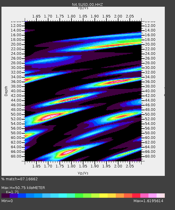
| Estimated Moho Depth: |
50.75 km |
| Estimated Crust Vp/Vs: |
1.71 |
| Assumed Crust Vp: |
6.53 km/s |
| Estimated Crust Vs: |
3.819 km/s |
| Estimated Crust Poisson's Ratio: |
0.24 |
|
| Radial Match: |
87.16662 % |
| Radial Bump: |
400 |
| Transverse Match: |
70.129036 % |
| Transverse Bump: |
400 |
| SOD ConfigId: |
21709731 |
| Insert Time: |
2020-09-15 21:19:40.302 +0000 |
| GWidth: |
2.5 |
| Max Bumps: |
400 |
| Tol: |
0.001 |
|

Signal To Noise
| Channel | StoN | STA | LTA |
| N4:SUSD:00:HHZ:20200901T21:20:34.318973Z | 4.30417 | 5.025647E-7 | 1.1676229E-7 |
| N4:SUSD:00:HH1:20200901T21:20:34.318973Z | 0.9916946 | 2.2235244E-7 | 2.2421462E-7 |
| N4:SUSD:00:HH2:20200901T21:20:34.318973Z | 0.70271707 | 1.6180142E-7 | 2.3025117E-7 |
| Arrivals |
| Ps | 5.7 SECOND |
| PpPs | 20 SECOND |
| PsPs/PpSs | 26 SECOND |


