You are here: Home > Network List > NN - Western Great Basin/Eastern Sierra Nevada Stations List
> Station PRN Pahroc Range, Nevada. (GPS 12/04/2000) w84 > Earthquake Result Viewer
PRN Pahroc Range, Nevada. (GPS 12/04/2000) w84 - Earthquake Result Viewer
| Earthquake location: |
Near Coast Of Northern Chile |
| Earthquake latitude/longitude: |
-27.9/-71.4 |
| Earthquake time(UTC): |
2020/09/01 (245) 21:09:17 GMT |
| Earthquake Depth: |
14 km |
| Earthquake Magnitude: |
6.5 mww |
| Earthquake Catalog/Contributor: |
NEIC PDE/us |
|
| Network: |
NN Western Great Basin/Eastern Sierra Nevada |
| Station: |
PRN Pahroc Range, Nevada. (GPS 12/04/2000) w84 |
| Lat/Lon: |
37.41 N/115.05 W |
| Elevation: |
1464 m |
|
| Distance: |
76.8 deg |
| Az: |
325.626 deg |
| Baz: |
141.145 deg |
| Ray Param: |
0.05073007 |
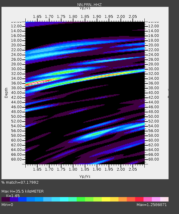
| Estimated Moho Depth: |
35.5 km |
| Estimated Crust Vp/Vs: |
1.65 |
| Assumed Crust Vp: |
6.276 km/s |
| Estimated Crust Vs: |
3.804 km/s |
| Estimated Crust Poisson's Ratio: |
0.21 |
|
| Radial Match: |
87.17992 % |
| Radial Bump: |
400 |
| Transverse Match: |
50.387684 % |
| Transverse Bump: |
400 |
| SOD ConfigId: |
21709731 |
| Insert Time: |
2020-09-15 21:20:57.624 +0000 |
| GWidth: |
2.5 |
| Max Bumps: |
400 |
| Tol: |
0.001 |
|

Signal To Noise
| Channel | StoN | STA | LTA |
| NN:PRN: :HHZ:20200901T21:20:37.249026Z | 0.64014643 | 9.674707E-8 | 1.5113272E-7 |
| NN:PRN: :HHN:20200901T21:20:37.249026Z | 0.57650673 | 1.5992136E-7 | 2.773972E-7 |
| NN:PRN: :HHE:20200901T21:20:37.249026Z | 1.2051173 | 2.1521646E-7 | 1.7858548E-7 |
| Arrivals |
| Ps | 3.8 SECOND |
| PpPs | 15 SECOND |
| PsPs/PpSs | 18 SECOND |


