You are here: Home > Network List > US - United States National Seismic Network Stations List
> Station HDIL Hopedale, Illinois, USA > Earthquake Result Viewer
HDIL Hopedale, Illinois, USA - Earthquake Result Viewer
| Earthquake location: |
Near Coast Of Northern Chile |
| Earthquake latitude/longitude: |
-27.9/-71.4 |
| Earthquake time(UTC): |
2020/09/01 (245) 21:09:17 GMT |
| Earthquake Depth: |
14 km |
| Earthquake Magnitude: |
6.5 mww |
| Earthquake Catalog/Contributor: |
NEIC PDE/us |
|
| Network: |
US United States National Seismic Network |
| Station: |
HDIL Hopedale, Illinois, USA |
| Lat/Lon: |
40.56 N/89.29 W |
| Elevation: |
219 m |
|
| Distance: |
70.1 deg |
| Az: |
345.582 deg |
| Baz: |
163.192 deg |
| Ray Param: |
0.05519058 |
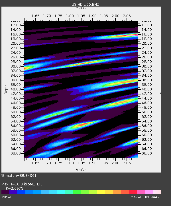
| Estimated Moho Depth: |
16.0 km |
| Estimated Crust Vp/Vs: |
2.10 |
| Assumed Crust Vp: |
6.498 km/s |
| Estimated Crust Vs: |
3.098 km/s |
| Estimated Crust Poisson's Ratio: |
0.35 |
|
| Radial Match: |
89.34061 % |
| Radial Bump: |
400 |
| Transverse Match: |
68.490486 % |
| Transverse Bump: |
400 |
| SOD ConfigId: |
21709731 |
| Insert Time: |
2020-09-15 21:26:42.638 +0000 |
| GWidth: |
2.5 |
| Max Bumps: |
400 |
| Tol: |
0.001 |
|

Signal To Noise
| Channel | StoN | STA | LTA |
| US:HDIL:00:BHZ:20200901T21:19:58.000003Z | 3.7213786 | 6.443323E-7 | 1.7314346E-7 |
| US:HDIL:00:BH1:20200901T21:19:58.000003Z | 1.6082709 | 2.9413982E-7 | 1.8289197E-7 |
| US:HDIL:00:BH2:20200901T21:19:58.000003Z | 2.063667 | 2.1852601E-7 | 1.0589209E-7 |
| Arrivals |
| Ps | 2.8 SECOND |
| PpPs | 7.4 SECOND |
| PsPs/PpSs | 10 SECOND |


