You are here: Home > Network List > XB93 - Southwest Pacific Seismic Experiment Stations List
> Station LBSA Labasa, Fiji > Earthquake Result Viewer
LBSA Labasa, Fiji - Earthquake Result Viewer
| Earthquake location: |
Macquarie Island Region |
| Earthquake latitude/longitude: |
-58.8/158.3 |
| Earthquake time(UTC): |
1995/10/13 (286) 15:22:23 GMT |
| Earthquake Depth: |
10 km |
| Earthquake Magnitude: |
5.6 MB, 5.9 MS, 6.1 UNKNOWN, 6.1 MW |
| Earthquake Catalog/Contributor: |
WHDF/NEIC |
|
| Network: |
XB Southwest Pacific Seismic Experiment |
| Station: |
LBSA Labasa, Fiji |
| Lat/Lon: |
16.30 S/179.45 E |
| Elevation: |
10 m |
|
| Distance: |
45.2 deg |
| Az: |
29.183 deg |
| Baz: |
195.314 deg |
| Ray Param: |
0.071410805 |
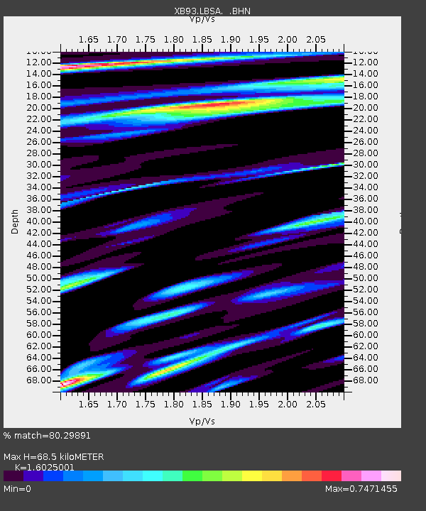
| Estimated Moho Depth: |
68.5 km |
| Estimated Crust Vp/Vs: |
1.60 |
| Assumed Crust Vp: |
5.195 km/s |
| Estimated Crust Vs: |
3.242 km/s |
| Estimated Crust Poisson's Ratio: |
0.18 |
|
| Radial Match: |
80.29891 % |
| Radial Bump: |
393 |
| Transverse Match: |
61.32627 % |
| Transverse Bump: |
338 |
| SOD ConfigId: |
6273 |
| Insert Time: |
2010-03-09 00:46:23.432 +0000 |
| GWidth: |
2.5 |
| Max Bumps: |
400 |
| Tol: |
0.001 |
|

Signal To Noise
| Channel | StoN | STA | LTA |
| XB:LBSA: :BHN:19951013T15:30:10.154987Z | 2.454725 | 8.446175E-7 | 3.4407827E-7 |
| XB:LBSA: :BHE:19951013T15:30:10.154987Z | 1.491432 | 5.7654415E-7 | 3.865709E-7 |
| XB:LBSA: :BHZ:19951013T15:30:10.154987Z | 7.5059123 | 1.913238E-6 | 2.548975E-7 |
| Arrivals |
| Ps | 8.3 SECOND |
| PpPs | 33 SECOND |
| PsPs/PpSs | 41 SECOND |


