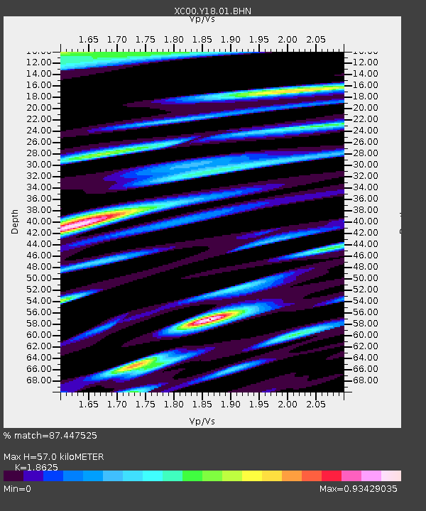
Y18 Y18 - Earthquake Result Viewer
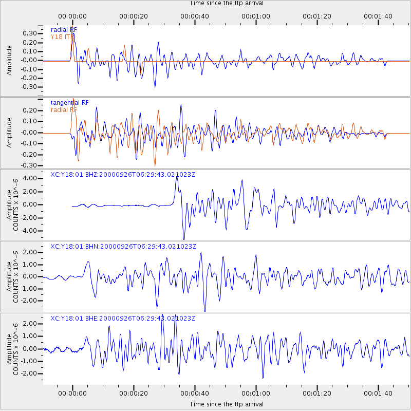
Earthquake location: Tonga Islands
Earthquake latitude/longitude: -17.2/-173.9
Earthquake time(UTC): 2000/09/26 (270) 06:17:52 GMT
Earthquake Depth: 56 km
Earthquake Magnitude: 6.1 MB, 6.1 MS, 6.4 MW, 6.1 ME
Earthquake Catalog/Contributor: WHDF/NEIC
Network: XC Yellowstone Intermountain Seismic Array
Station: Y18 Y18
Lat/Lon: 43.75 N/111.03 W
Elevation: 1998 m
Distance: 83.5 deg
Az: 40.488 deg
Baz: 238.927 deg
Ray Param: 0.046045996
Estimated Moho Depth: 57.0 km
Estimated Crust Vp/Vs: 1.86
Assumed Crust Vp: 6.207 km/s
Estimated Crust Vs: 3.332 km/s
Estimated Crust Poisson's Ratio: 0.30
Radial Match: 87.447525 %
Radial Bump: 400
Transverse Match: 86.46899 %
Transverse Bump: 400
SOD ConfigId: 16820
Insert Time: 2010-02-26 15:05:05.928 +0000
GWidth: 2.5
Max Bumps: 400
Tol: 0.001

Signal To Noise

ChannelStoNSTALTA
XC:Y18:01:BHN:20000926T06:29:43.021023Z3.37444574.2244073E-71.251882E-7
XC:Y18:01:BHE:20000926T06:29:43.021023Z2.9594523.650709E-71.233576E-7
XC:Y18:01:BHZ:20000926T06:29:43.021023Z17.1361161.6934729E-69.882478E-8
Arrivals
Ps8.1 SECOND
PpPs26 SECOND
PsPs/PpSs34 SECOND