You are here: Home > Network List > XC00 - Yellowstone Intermountain Seismic Array Stations List
> Station Y18 Y18 > Earthquake Result Viewer
Y18 Y18 - Earthquake Result Viewer
| Earthquake location: |
Tonga Islands |
| Earthquake latitude/longitude: |
-15.9/-173.7 |
| Earthquake time(UTC): |
2000/09/11 (255) 17:17:53 GMT |
| Earthquake Depth: |
115 km |
| Earthquake Magnitude: |
6.0 MB, 6.3 MW, 6.3 MW |
| Earthquake Catalog/Contributor: |
WHDF/NEIC |
|
| Network: |
XC Yellowstone Intermountain Seismic Array |
| Station: |
Y18 Y18 |
| Lat/Lon: |
43.75 N/111.03 W |
| Elevation: |
1998 m |
|
| Distance: |
82.4 deg |
| Az: |
40.504 deg |
| Baz: |
239.6 deg |
| Ray Param: |
0.04668298 |
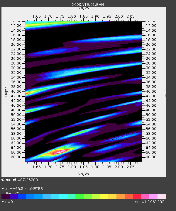
| Estimated Moho Depth: |
65.5 km |
| Estimated Crust Vp/Vs: |
1.75 |
| Assumed Crust Vp: |
6.207 km/s |
| Estimated Crust Vs: |
3.547 km/s |
| Estimated Crust Poisson's Ratio: |
0.26 |
|
| Radial Match: |
87.26283 % |
| Radial Bump: |
400 |
| Transverse Match: |
78.74064 % |
| Transverse Bump: |
400 |
| SOD ConfigId: |
16820 |
| Insert Time: |
2010-02-26 15:05:06.863 +0000 |
| GWidth: |
2.5 |
| Max Bumps: |
400 |
| Tol: |
0.001 |
|

Signal To Noise
| Channel | StoN | STA | LTA |
| XC:Y18:01:BHN:20000911T17:29:31.42002Z | 1.9299206 | 3.148198E-7 | 1.6312579E-7 |
| XC:Y18:01:BHE:20000911T17:29:31.42002Z | 6.026007 | 4.4863222E-7 | 7.444934E-8 |
| XC:Y18:01:BHZ:20000911T17:29:31.42002Z | 10.5718155 | 1.9087502E-6 | 1.8055083E-7 |
| Arrivals |
| Ps | 8.1 SECOND |
| PpPs | 28 SECOND |
| PsPs/PpSs | 36 SECOND |


