You are here: Home > Network List > TA - USArray Transportable Network (new EarthScope stations) Stations List
> Station C16K Lisburne Hills, AK, USA > Earthquake Result Viewer
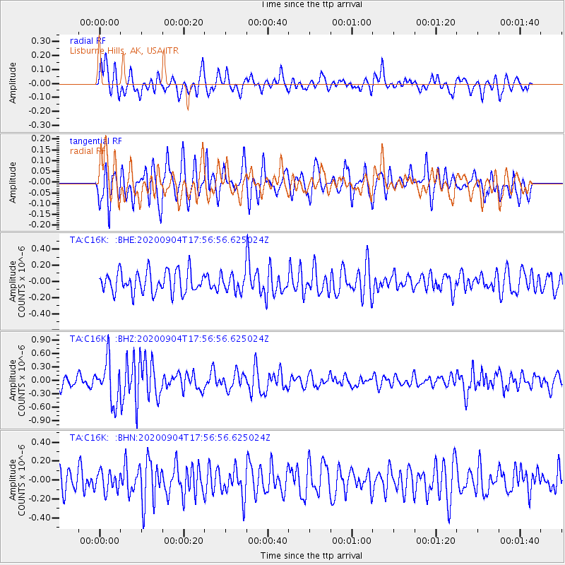
C16K Lisburne Hills, AK, USA - Earthquake Result Viewer
*The percent match for this event was below the threshold and hence no stack was calculated.
| Earthquake location: |
Panama-Costa Rica Border Region |
| Earthquake latitude/longitude: |
8.3/-83.0 |
| Earthquake time(UTC): |
2020/09/04 (248) 17:45:21 GMT |
| Earthquake Depth: |
8.7 km |
| Earthquake Magnitude: |
5.6 Mww |
| Earthquake Catalog/Contributor: |
NEIC PDE/us |
|
| Network: |
TA USArray Transportable Network (new EarthScope stations) |
| Station: |
C16K Lisburne Hills, AK, USA |
| Lat/Lon: |
68.27 N/165.34 W |
| Elevation: |
102 m |
|
| Distance: |
79.5 deg |
| Az: |
337.956 deg |
| Baz: |
93.992 deg |
| Ray Param: |
$rayparam |
*The percent match for this event was below the threshold and hence was not used in the summary stack. |
|
| Radial Match: |
60.412945 % |
| Radial Bump: |
400 |
| Transverse Match: |
68.682236 % |
| Transverse Bump: |
400 |
| SOD ConfigId: |
22732711 |
| Insert Time: |
2020-09-18 18:07:25.526 +0000 |
| GWidth: |
2.5 |
| Max Bumps: |
400 |
| Tol: |
0.001 |
|
Signal To Noise
| Channel | StoN | STA | LTA |
| TA:C16K: :BHZ:20200904T17:56:56.625024Z | 3.6240065 | 4.7754037E-7 | 1.3177139E-7 |
| TA:C16K: :BHN:20200904T17:56:56.625024Z | 1.0579202 | 1.0081252E-7 | 9.529312E-8 |
| TA:C16K: :BHE:20200904T17:56:56.625024Z | 0.8126714 | 1.08243874E-7 | 1.3319513E-7 |
| Arrivals |
| Ps | |
| PpPs | |
| PsPs/PpSs | |


