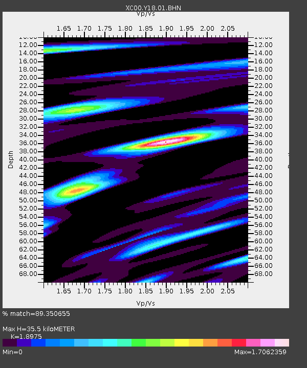
Y18 Y18 - Earthquake Result Viewer
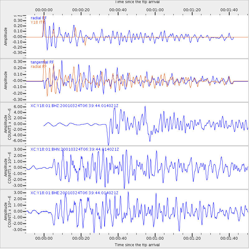
Earthquake location: Western Honshu, Japan
Earthquake latitude/longitude: 34.1/132.5
Earthquake time(UTC): 2001/03/24 (083) 06:27:53 GMT
Earthquake Depth: 50 km
Earthquake Magnitude: 6.4 MB, 6.5 MS, 6.8 MW, 6.4 ME
Earthquake Catalog/Contributor: WHDF/NEIC
Network: XC Yellowstone Intermountain Seismic Array
Station: Y18 Y18
Lat/Lon: 43.75 N/111.03 W
Elevation: 1998 m
Distance: 83.3 deg
Az: 40.79 deg
Baz: 311.564 deg
Ray Param: 0.04619337
Estimated Moho Depth: 35.5 km
Estimated Crust Vp/Vs: 1.90
Assumed Crust Vp: 6.207 km/s
Estimated Crust Vs: 3.271 km/s
Estimated Crust Poisson's Ratio: 0.31
Radial Match: 89.350655 %
Radial Bump: 400
Transverse Match: 86.560844 %
Transverse Bump: 400
SOD ConfigId: 4714
Insert Time: 2010-02-26 15:05:12.692 +0000
GWidth: 2.5
Max Bumps: 400
Tol: 0.001

Signal To Noise

ChannelStoNSTALTA
XC:Y18:01:BHN:20010324T06:39:44.014021Z0.52147761.260774E-72.4176956E-7
XC:Y18:01:BHE:20010324T06:39:44.014021Z1.85031593.6515914E-71.9734962E-7
XC:Y18:01:BHZ:20010324T06:39:44.014021Z5.84471941.9389033E-63.3173592E-7
Arrivals
Ps5.2 SECOND
PpPs16 SECOND
PsPs/PpSs21 SECOND