Y18 Y18 - Earthquake Result Viewer
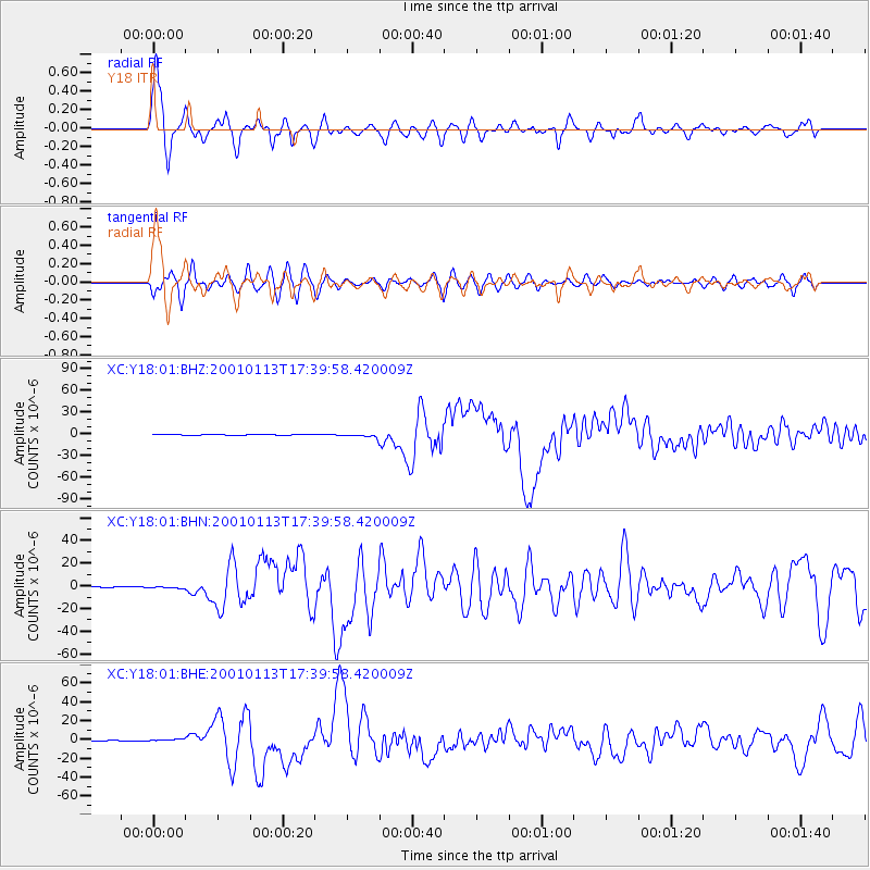
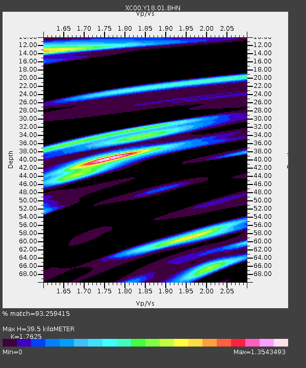
Earthquake location: El Salvador
Earthquake latitude/longitude: 13.0/-88.7
Earthquake time(UTC): 2001/01/13 (013) 17:33:32 GMT
Earthquake Depth: 60 km
Earthquake Magnitude: 6.4 MB, 7.8 MS, 7.7 MW, 7.5 ME
Earthquake Catalog/Contributor: WHDF/NEIC
Network: XC Yellowstone Intermountain Seismic Array
Station: Y18 Y18
Lat/Lon: 43.75 N/111.03 W
Elevation: 1998 m
Distance: 36.1 deg
Az: 332.115 deg
Baz: 141.028 deg
Ray Param: 0.07668231
Estimated Moho Depth: 39.5 km
Estimated Crust Vp/Vs: 1.76
Assumed Crust Vp: 6.207 km/s
Estimated Crust Vs: 3.522 km/s
Estimated Crust Poisson's Ratio: 0.26
Radial Match: 93.259415 %
Radial Bump: 400
Transverse Match: 85.767166 %
Transverse Bump: 400
SOD ConfigId: 16820
Insert Time: 2010-02-26 15:05:13.559 +0000
GWidth: 2.5
Max Bumps: 400
Tol: 0.001

Signal To Noise

ChannelStoNSTALTA
XC:Y18:01:BHN:20010113T17:39:58.420009Z2.2142858.950706E-74.042256E-7
XC:Y18:01:BHE:20010113T17:39:58.420009Z3.02989361.1208358E-63.6992577E-7
XC:Y18:01:BHZ:20010113T17:39:58.420009Z4.12107372.370335E-65.751741E-7
Arrivals
Ps5.2 SECOND
PpPs16 SECOND
PsPs/PpSs22 SECOND