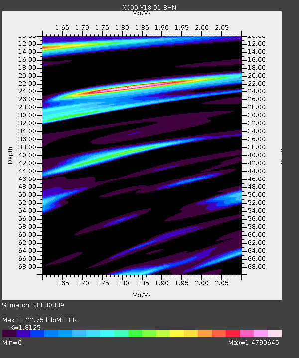
Y18 Y18 - Earthquake Result Viewer
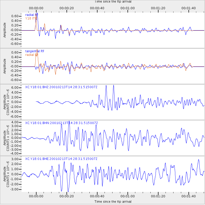
Earthquake location: El Salvador
Earthquake latitude/longitude: 13.7/-88.9
Earthquake time(UTC): 2001/02/13 (044) 14:22:05 GMT
Earthquake Depth: 10 km
Earthquake Magnitude: 5.5 MB, 6.5 MS, 6.6 MW, 6.1 MD
Earthquake Catalog/Contributor: WHDF/NEIC
Network: XC Yellowstone Intermountain Seismic Array
Station: Y18 Y18
Lat/Lon: 43.75 N/111.03 W
Elevation: 1998 m
Distance: 35.5 deg
Az: 331.981 deg
Baz: 140.941 deg
Ray Param: 0.077212185
Estimated Moho Depth: 22.75 km
Estimated Crust Vp/Vs: 1.81
Assumed Crust Vp: 6.207 km/s
Estimated Crust Vs: 3.424 km/s
Estimated Crust Poisson's Ratio: 0.28
Radial Match: 88.30889 %
Radial Bump: 377
Transverse Match: 75.93338 %
Transverse Bump: 400
SOD ConfigId: 3744
Insert Time: 2010-02-26 15:05:17.022 +0000
GWidth: 2.5
Max Bumps: 400
Tol: 0.001

Signal To Noise

ChannelStoNSTALTA
XC:Y18:01:BHN:20010213T14:28:31.515007Z0.388325631.08543325E-72.7951626E-7
XC:Y18:01:BHE:20010213T14:28:31.515007Z1.50100724.030087E-72.684922E-7
XC:Y18:01:BHZ:20010213T14:28:31.515007Z0.782199862.555862E-73.2675308E-7
Arrivals
Ps3.2 SECOND
PpPs9.6 SECOND
PsPs/PpSs13 SECOND