You are here: Home > Network List > AK - Alaska Regional Network Stations List
> Station I21K Tanana, AK, USA > Earthquake Result Viewer
I21K Tanana, AK, USA - Earthquake Result Viewer
| Earthquake location: |
Northern Molucca Sea |
| Earthquake latitude/longitude: |
1.7/126.6 |
| Earthquake time(UTC): |
2020/09/06 (250) 00:21:10 GMT |
| Earthquake Depth: |
30 km |
| Earthquake Magnitude: |
5.9 Mww |
| Earthquake Catalog/Contributor: |
NEIC PDE/us |
|
| Network: |
AK Alaska Regional Network |
| Station: |
I21K Tanana, AK, USA |
| Lat/Lon: |
65.18 N/151.98 W |
| Elevation: |
248 m |
|
| Distance: |
84.9 deg |
| Az: |
24.776 deg |
| Baz: |
262.94 deg |
| Ray Param: |
0.04511877 |
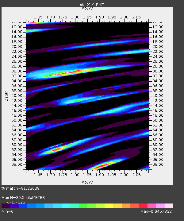
| Estimated Moho Depth: |
30.5 km |
| Estimated Crust Vp/Vs: |
1.75 |
| Assumed Crust Vp: |
6.566 km/s |
| Estimated Crust Vs: |
3.747 km/s |
| Estimated Crust Poisson's Ratio: |
0.26 |
|
| Radial Match: |
81.25039 % |
| Radial Bump: |
365 |
| Transverse Match: |
64.81376 % |
| Transverse Bump: |
400 |
| SOD ConfigId: |
22732711 |
| Insert Time: |
2020-09-20 00:24:21.831 +0000 |
| GWidth: |
2.5 |
| Max Bumps: |
400 |
| Tol: |
0.001 |
|

Signal To Noise
| Channel | StoN | STA | LTA |
| AK:I21K: :BHZ:20200906T00:33:11.519989Z | 7.2861276 | 4.6998437E-7 | 6.4504E-8 |
| AK:I21K: :BHN:20200906T00:33:11.519989Z | 1.1775401 | 1.6027289E-7 | 1.3610823E-7 |
| AK:I21K: :BHE:20200906T00:33:11.519989Z | 2.2305496 | 2.3176517E-7 | 1.0390496E-7 |
| Arrivals |
| Ps | 3.6 SECOND |
| PpPs | 12 SECOND |
| PsPs/PpSs | 16 SECOND |


