You are here: Home > Network List > AK - Alaska Regional Network Stations List
> Station L19K White Mountain, AK, USA > Earthquake Result Viewer
L19K White Mountain, AK, USA - Earthquake Result Viewer
| Earthquake location: |
Northern Molucca Sea |
| Earthquake latitude/longitude: |
1.7/126.6 |
| Earthquake time(UTC): |
2020/09/06 (250) 00:21:10 GMT |
| Earthquake Depth: |
30 km |
| Earthquake Magnitude: |
5.9 Mww |
| Earthquake Catalog/Contributor: |
NEIC PDE/us |
|
| Network: |
AK Alaska Regional Network |
| Station: |
L19K White Mountain, AK, USA |
| Lat/Lon: |
62.18 N/154.85 W |
| Elevation: |
650 m |
|
| Distance: |
83.2 deg |
| Az: |
27.587 deg |
| Baz: |
260.66 deg |
| Ray Param: |
0.04631957 |
| Estimated Moho Depth: |
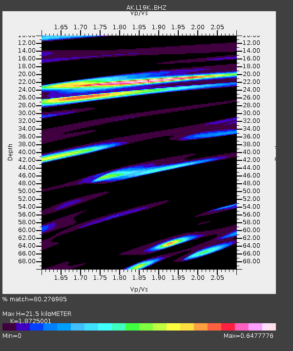
21.5 km |
| Estimated Crust Vp/Vs: |
1.87 |
| Assumed Crust Vp: |
6.438 km/s |
| Estimated Crust Vs: |
3.438 km/s |
| Estimated Crust Poisson's Ratio: |
0.30 |
|
| Radial Match: |
80.276985 % |
| Radial Bump: |
400 |
| Transverse Match: |
65.01897 % |
| Transverse Bump: |
400 |
| SOD ConfigId: |
22732711 |
| Insert Time: |
2020-09-20 00:24:42.468 +0000 |
| GWidth: |
2.5 |
| Max Bumps: |
400 |
| Tol: |
0.001 |
|

Signal To Noise
| Channel | StoN | STA | LTA |
| AK:L19K: :BHZ:20200906T00:33:02.920013Z | 7.903246 | 9.4181473E-7 | 1.19168085E-7 |
| AK:L19K: :BHN:20200906T00:33:02.920013Z | 0.7118338 | 1.4712295E-7 | 2.0668159E-7 |
| AK:L19K: :BHE:20200906T00:33:02.920013Z | 2.5341709 | 3.060384E-7 | 1.2076471E-7 |
| Arrivals |
| Ps | 3.0 SECOND |
| PpPs | 9.4 SECOND |
| PsPs/PpSs | 12 SECOND |


