You are here: Home > Network List > US - United States National Seismic Network Stations List
> Station AMTX Amarillo, Texas, USA > Earthquake Result Viewer
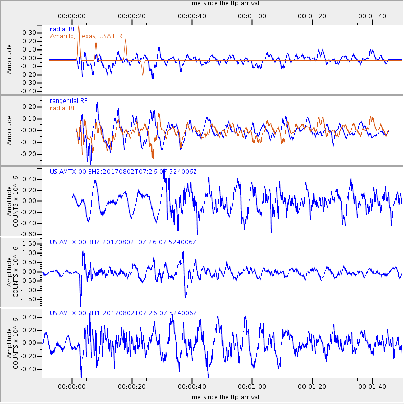
AMTX Amarillo, Texas, USA - Earthquake Result Viewer
*The percent match for this event was below the threshold and hence no stack was calculated.
| Earthquake location: |
Chile-Argentina Border Region |
| Earthquake latitude/longitude: |
-33.2/-70.6 |
| Earthquake time(UTC): |
2017/08/02 (214) 07:15:13 GMT |
| Earthquake Depth: |
88 km |
| Earthquake Magnitude: |
5.5 Mww |
| Earthquake Catalog/Contributor: |
NEIC PDE/us |
|
| Network: |
US United States National Seismic Network |
| Station: |
AMTX Amarillo, Texas, USA |
| Lat/Lon: |
34.53 N/101.41 W |
| Elevation: |
1010 m |
|
| Distance: |
73.3 deg |
| Az: |
333.834 deg |
| Baz: |
153.398 deg |
| Ray Param: |
$rayparam |
*The percent match for this event was below the threshold and hence was not used in the summary stack. |
|
| Radial Match: |
65.417885 % |
| Radial Bump: |
400 |
| Transverse Match: |
62.441406 % |
| Transverse Bump: |
400 |
| SOD ConfigId: |
2140511 |
| Insert Time: |
2017-08-15 23:10:55.058 +0000 |
| GWidth: |
2.5 |
| Max Bumps: |
400 |
| Tol: |
0.001 |
|
Signal To Noise
| Channel | StoN | STA | LTA |
| US:AMTX:00:BHZ:20170802T07:26:07.524006Z | 5.3238525 | 5.5002425E-7 | 1.033132E-7 |
| US:AMTX:00:BH1:20170802T07:26:07.524006Z | 1.6512452 | 1.8055232E-7 | 1.09343134E-7 |
| US:AMTX:00:BH2:20170802T07:26:07.524006Z | 1.9168478 | 3.0771736E-7 | 1.6053302E-7 |
| Arrivals |
| Ps | |
| PpPs | |
| PsPs/PpSs | |


