You are here: Home > Network List > TA - USArray Transportable Network (new EarthScope stations) Stations List
> Station A22K Sinclair Lake, AK, USA > Earthquake Result Viewer
A22K Sinclair Lake, AK, USA - Earthquake Result Viewer
| Earthquake location: |
Northern Molucca Sea |
| Earthquake latitude/longitude: |
1.7/126.6 |
| Earthquake time(UTC): |
2020/09/06 (250) 00:21:10 GMT |
| Earthquake Depth: |
30 km |
| Earthquake Magnitude: |
5.9 Mww |
| Earthquake Catalog/Contributor: |
NEIC PDE/us |
|
| Network: |
TA USArray Transportable Network (new EarthScope stations) |
| Station: |
A22K Sinclair Lake, AK, USA |
| Lat/Lon: |
71.00 N/154.97 W |
| Elevation: |
6.0 m |
|
| Distance: |
84.7 deg |
| Az: |
18.799 deg |
| Baz: |
259.62 deg |
| Ray Param: |
0.045279916 |
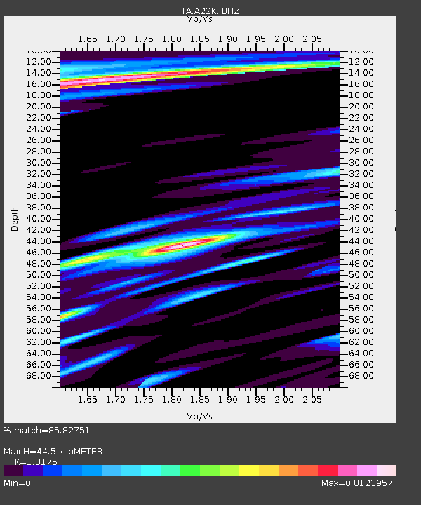
| Estimated Moho Depth: |
44.5 km |
| Estimated Crust Vp/Vs: |
1.82 |
| Assumed Crust Vp: |
5.782 km/s |
| Estimated Crust Vs: |
3.181 km/s |
| Estimated Crust Poisson's Ratio: |
0.28 |
|
| Radial Match: |
85.82751 % |
| Radial Bump: |
400 |
| Transverse Match: |
80.955765 % |
| Transverse Bump: |
400 |
| SOD ConfigId: |
22732711 |
| Insert Time: |
2020-09-20 00:31:54.244 +0000 |
| GWidth: |
2.5 |
| Max Bumps: |
400 |
| Tol: |
0.001 |
|

Signal To Noise
| Channel | StoN | STA | LTA |
| TA:A22K: :BHZ:20200906T00:33:10.399994Z | 4.8958035 | 1.4451346E-6 | 2.951782E-7 |
| TA:A22K: :BHN:20200906T00:33:10.399994Z | 0.8093978 | 2.4408155E-7 | 3.0155942E-7 |
| TA:A22K: :BHE:20200906T00:33:10.399994Z | 1.2569575 | 3.3549156E-7 | 2.6690765E-7 |
| Arrivals |
| Ps | 6.4 SECOND |
| PpPs | 21 SECOND |
| PsPs/PpSs | 28 SECOND |


