You are here: Home > Network List > TA - USArray Transportable Network (new EarthScope stations) Stations List
> Station B18K Kokolik River, AK, USA > Earthquake Result Viewer
B18K Kokolik River, AK, USA - Earthquake Result Viewer
| Earthquake location: |
Northern Molucca Sea |
| Earthquake latitude/longitude: |
1.7/126.6 |
| Earthquake time(UTC): |
2020/09/06 (250) 00:21:10 GMT |
| Earthquake Depth: |
30 km |
| Earthquake Magnitude: |
5.9 Mww |
| Earthquake Catalog/Contributor: |
NEIC PDE/us |
|
| Network: |
TA USArray Transportable Network (new EarthScope stations) |
| Station: |
B18K Kokolik River, AK, USA |
| Lat/Lon: |
69.36 N/161.80 W |
| Elevation: |
222 m |
|
| Distance: |
82.0 deg |
| Az: |
19.861 deg |
| Baz: |
253.323 deg |
| Ray Param: |
0.047133032 |
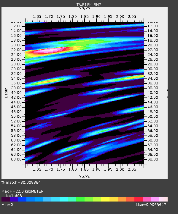
| Estimated Moho Depth: |
22.0 km |
| Estimated Crust Vp/Vs: |
1.70 |
| Assumed Crust Vp: |
5.906 km/s |
| Estimated Crust Vs: |
3.485 km/s |
| Estimated Crust Poisson's Ratio: |
0.23 |
|
| Radial Match: |
80.608864 % |
| Radial Bump: |
400 |
| Transverse Match: |
73.19893 % |
| Transverse Bump: |
400 |
| SOD ConfigId: |
22732711 |
| Insert Time: |
2020-09-20 00:31:57.357 +0000 |
| GWidth: |
2.5 |
| Max Bumps: |
400 |
| Tol: |
0.001 |
|
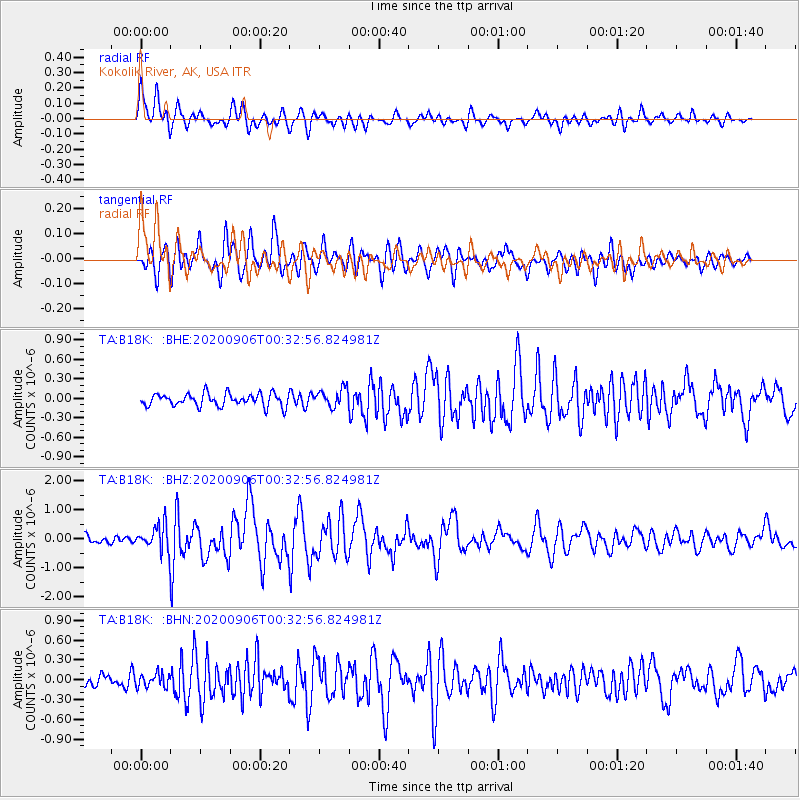
Signal To Noise
| Channel | StoN | STA | LTA |
| TA:B18K: :BHZ:20200906T00:32:56.824981Z | 2.7622337 | 4.4188985E-7 | 1.5997556E-7 |
| TA:B18K: :BHN:20200906T00:32:56.824981Z | 1.0439842 | 1.0317059E-7 | 9.8823904E-8 |
| TA:B18K: :BHE:20200906T00:32:56.824981Z | 1.4299816 | 1.393955E-7 | 9.7480616E-8 |
| Arrivals |
| Ps | 2.7 SECOND |
| PpPs | 9.8 SECOND |
| PsPs/PpSs | 12 SECOND |


