You are here: Home > Network List > TA - USArray Transportable Network (new EarthScope stations) Stations List
> Station C16K Lisburne Hills, AK, USA > Earthquake Result Viewer
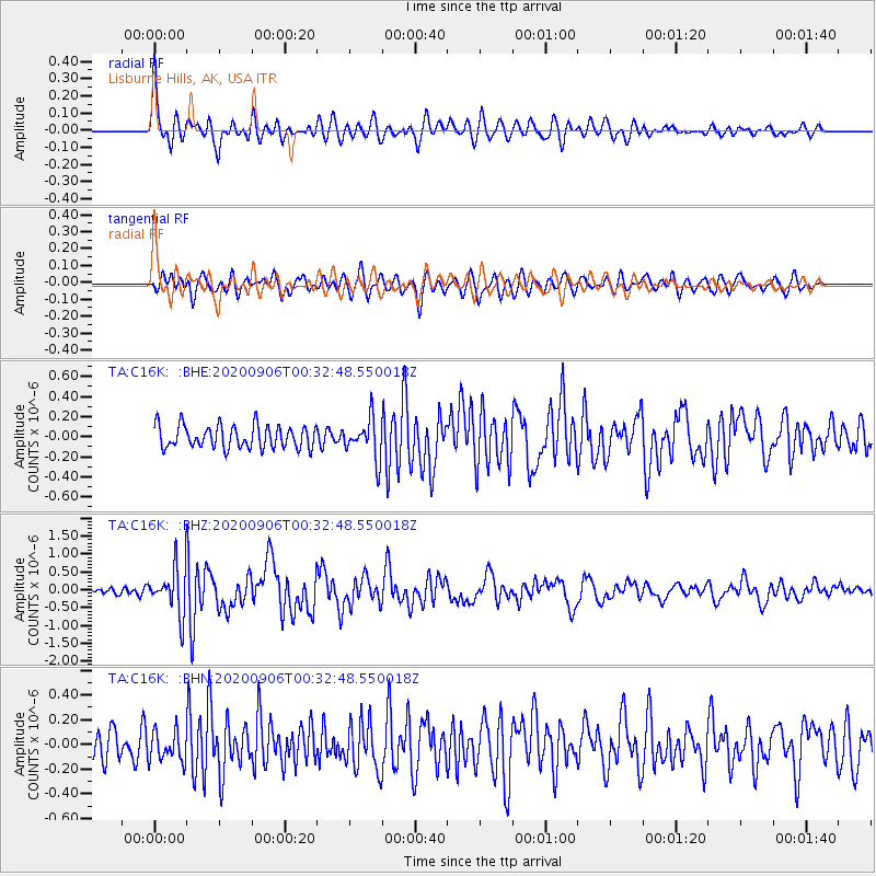
C16K Lisburne Hills, AK, USA - Earthquake Result Viewer
| Earthquake location: |
Northern Molucca Sea |
| Earthquake latitude/longitude: |
1.7/126.6 |
| Earthquake time(UTC): |
2020/09/06 (250) 00:21:10 GMT |
| Earthquake Depth: |
30 km |
| Earthquake Magnitude: |
5.9 Mww |
| Earthquake Catalog/Contributor: |
NEIC PDE/us |
|
| Network: |
TA USArray Transportable Network (new EarthScope stations) |
| Station: |
C16K Lisburne Hills, AK, USA |
| Lat/Lon: |
68.27 N/165.34 W |
| Elevation: |
102 m |
|
| Distance: |
80.5 deg |
| Az: |
20.504 deg |
| Baz: |
250.121 deg |
| Ray Param: |
0.04822137 |
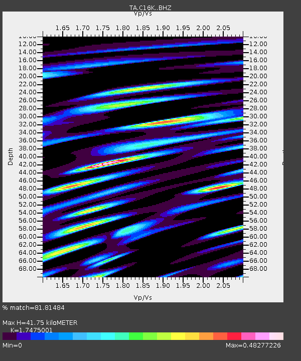
| Estimated Moho Depth: |
41.75 km |
| Estimated Crust Vp/Vs: |
1.75 |
| Assumed Crust Vp: |
5.906 km/s |
| Estimated Crust Vs: |
3.38 km/s |
| Estimated Crust Poisson's Ratio: |
0.26 |
|
| Radial Match: |
81.81484 % |
| Radial Bump: |
400 |
| Transverse Match: |
73.339554 % |
| Transverse Bump: |
400 |
| SOD ConfigId: |
22732711 |
| Insert Time: |
2020-09-20 00:32:02.411 +0000 |
| GWidth: |
2.5 |
| Max Bumps: |
400 |
| Tol: |
0.001 |
|
Signal To Noise
| Channel | StoN | STA | LTA |
| TA:C16K: :BHZ:20200906T00:32:48.550018Z | 6.0817194 | 6.5002104E-7 | 1.0688113E-7 |
| TA:C16K: :BHN:20200906T00:32:48.550018Z | 1.1766777 | 1.2375195E-7 | 1.05170635E-7 |
| TA:C16K: :BHE:20200906T00:32:48.550018Z | 1.7581519 | 1.9684347E-7 | 1.1196044E-7 |
| Arrivals |
| Ps | 5.4 SECOND |
| PpPs | 19 SECOND |
| PsPs/PpSs | 24 SECOND |


