You are here: Home > Network List > TA - USArray Transportable Network (new EarthScope stations) Stations List
> Station E20K Nigu River, AK, USA > Earthquake Result Viewer
E20K Nigu River, AK, USA - Earthquake Result Viewer
| Earthquake location: |
Northern Molucca Sea |
| Earthquake latitude/longitude: |
1.7/126.6 |
| Earthquake time(UTC): |
2020/09/06 (250) 00:21:10 GMT |
| Earthquake Depth: |
30 km |
| Earthquake Magnitude: |
5.9 Mww |
| Earthquake Catalog/Contributor: |
NEIC PDE/us |
|
| Network: |
TA USArray Transportable Network (new EarthScope stations) |
| Station: |
E20K Nigu River, AK, USA |
| Lat/Lon: |
68.26 N/156.19 W |
| Elevation: |
866 m |
|
| Distance: |
83.7 deg |
| Az: |
21.443 deg |
| Baz: |
258.749 deg |
| Ray Param: |
0.045937233 |
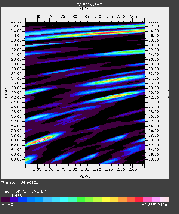
| Estimated Moho Depth: |
59.75 km |
| Estimated Crust Vp/Vs: |
1.66 |
| Assumed Crust Vp: |
6.221 km/s |
| Estimated Crust Vs: |
3.736 km/s |
| Estimated Crust Poisson's Ratio: |
0.22 |
|
| Radial Match: |
84.90101 % |
| Radial Bump: |
400 |
| Transverse Match: |
79.98856 % |
| Transverse Bump: |
400 |
| SOD ConfigId: |
22732711 |
| Insert Time: |
2020-09-20 00:32:27.949 +0000 |
| GWidth: |
2.5 |
| Max Bumps: |
400 |
| Tol: |
0.001 |
|
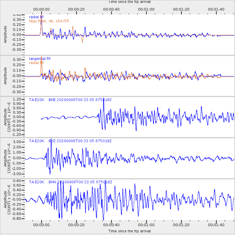
Signal To Noise
| Channel | StoN | STA | LTA |
| TA:E20K: :BHZ:20200906T00:33:05.675018Z | 11.115308 | 9.3492673E-7 | 8.411164E-8 |
| TA:E20K: :BHN:20200906T00:33:05.675018Z | 2.509911 | 1.234905E-7 | 4.920114E-8 |
| TA:E20K: :BHE:20200906T00:33:05.675018Z | 4.6410017 | 2.5224494E-7 | 5.4351403E-8 |
| Arrivals |
| Ps | 6.6 SECOND |
| PpPs | 25 SECOND |
| PsPs/PpSs | 32 SECOND |


