You are here: Home > Network List > TA - USArray Transportable Network (new EarthScope stations) Stations List
> Station F21K Alatna River, AK, USA > Earthquake Result Viewer
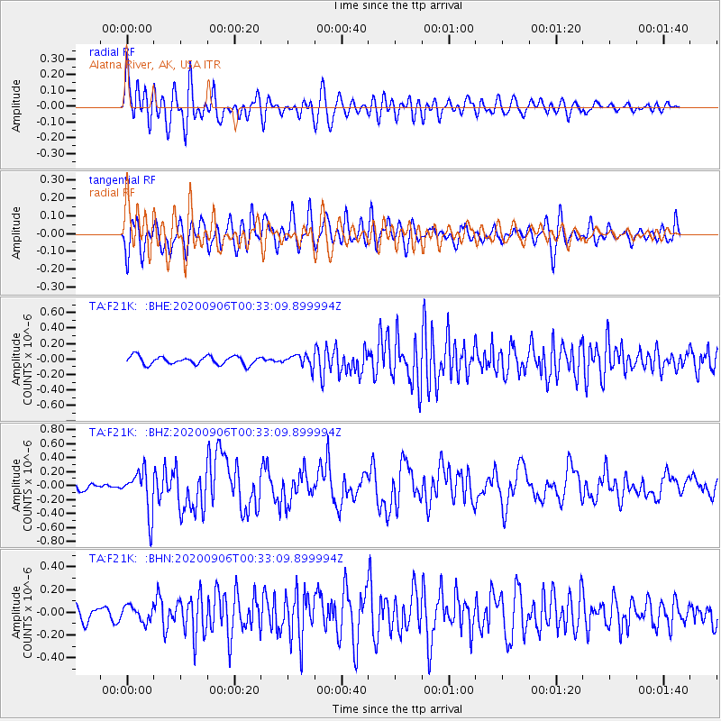
F21K Alatna River, AK, USA - Earthquake Result Viewer
*The percent match for this event was below the threshold and hence no stack was calculated.
| Earthquake location: |
Northern Molucca Sea |
| Earthquake latitude/longitude: |
1.7/126.6 |
| Earthquake time(UTC): |
2020/09/06 (250) 00:21:10 GMT |
| Earthquake Depth: |
30 km |
| Earthquake Magnitude: |
5.9 Mww |
| Earthquake Catalog/Contributor: |
NEIC PDE/us |
|
| Network: |
TA USArray Transportable Network (new EarthScope stations) |
| Station: |
F21K Alatna River, AK, USA |
| Lat/Lon: |
67.22 N/153.48 W |
| Elevation: |
597 m |
|
| Distance: |
84.6 deg |
| Az: |
22.652 deg |
| Baz: |
261.374 deg |
| Ray Param: |
$rayparam |
*The percent match for this event was below the threshold and hence was not used in the summary stack. |
|
| Radial Match: |
66.85883 % |
| Radial Bump: |
400 |
| Transverse Match: |
60.082787 % |
| Transverse Bump: |
400 |
| SOD ConfigId: |
22732711 |
| Insert Time: |
2020-09-20 00:32:48.272 +0000 |
| GWidth: |
2.5 |
| Max Bumps: |
400 |
| Tol: |
0.001 |
|
Signal To Noise
| Channel | StoN | STA | LTA |
| TA:F21K: :BHZ:20200906T00:33:09.899994Z | 3.9276347 | 3.1074956E-7 | 7.911875E-8 |
| TA:F21K: :BHN:20200906T00:33:09.899994Z | 1.1986877 | 6.78473E-8 | 5.660132E-8 |
| TA:F21K: :BHE:20200906T00:33:09.899994Z | 1.4957145 | 7.8572285E-8 | 5.2531608E-8 |
| Arrivals |
| Ps | |
| PpPs | |
| PsPs/PpSs | |


