You are here: Home > Network List > TA - USArray Transportable Network (new EarthScope stations) Stations List
> Station F26K Sheenjek River, AK, USA > Earthquake Result Viewer
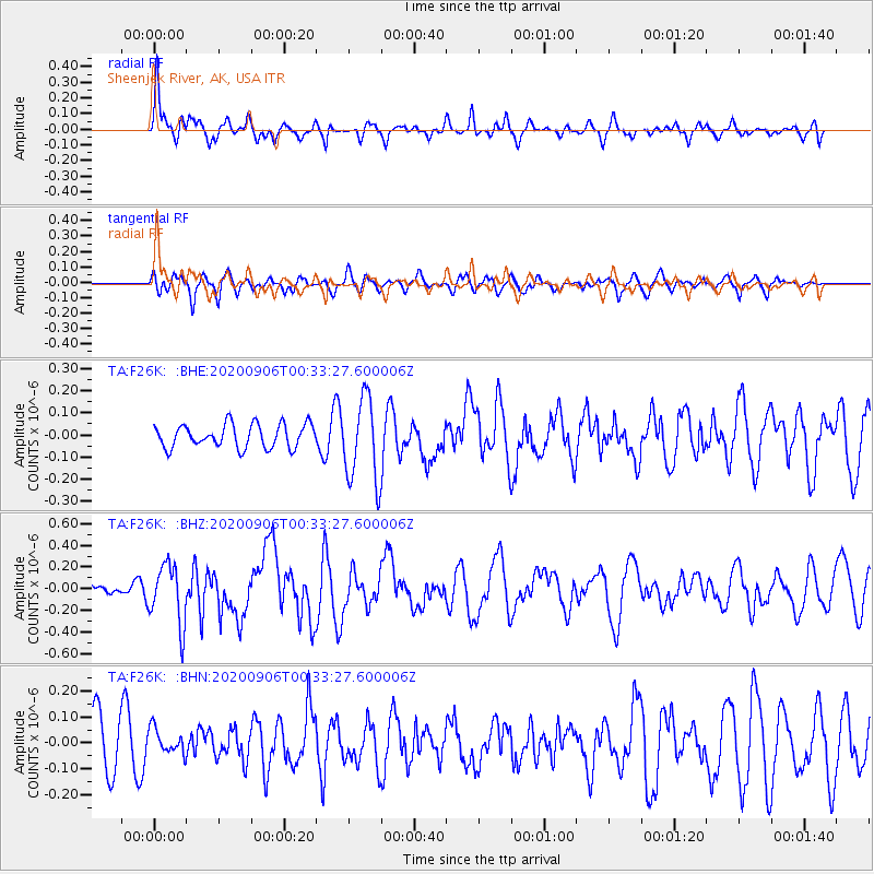
F26K Sheenjek River, AK, USA - Earthquake Result Viewer
*The percent match for this event was below the threshold and hence no stack was calculated.
| Earthquake location: |
Northern Molucca Sea |
| Earthquake latitude/longitude: |
1.7/126.6 |
| Earthquake time(UTC): |
2020/09/06 (250) 00:21:10 GMT |
| Earthquake Depth: |
30 km |
| Earthquake Magnitude: |
5.9 Mww |
| Earthquake Catalog/Contributor: |
NEIC PDE/us |
|
| Network: |
TA USArray Transportable Network (new EarthScope stations) |
| Station: |
F26K Sheenjek River, AK, USA |
| Lat/Lon: |
67.69 N/144.15 W |
| Elevation: |
683 m |
|
| Distance: |
88.2 deg |
| Az: |
22.451 deg |
| Baz: |
269.979 deg |
| Ray Param: |
$rayparam |
*The percent match for this event was below the threshold and hence was not used in the summary stack. |
|
| Radial Match: |
66.05305 % |
| Radial Bump: |
333 |
| Transverse Match: |
55.727745 % |
| Transverse Bump: |
400 |
| SOD ConfigId: |
22732711 |
| Insert Time: |
2020-09-20 00:32:53.507 +0000 |
| GWidth: |
2.5 |
| Max Bumps: |
400 |
| Tol: |
0.001 |
|
Signal To Noise
| Channel | StoN | STA | LTA |
| TA:F26K: :BHZ:20200906T00:33:27.600006Z | 2.5689886 | 2.7585395E-7 | 1.07378426E-7 |
| TA:F26K: :BHN:20200906T00:33:27.600006Z | 0.4602193 | 4.8958682E-8 | 1.0638121E-7 |
| TA:F26K: :BHE:20200906T00:33:27.600006Z | 3.583222 | 1.9003345E-7 | 5.303424E-8 |
| Arrivals |
| Ps | |
| PpPs | |
| PsPs/PpSs | |


