You are here: Home > Network List > TA - USArray Transportable Network (new EarthScope stations) Stations List
> Station H31M Peel River, Yukon, CAN > Earthquake Result Viewer
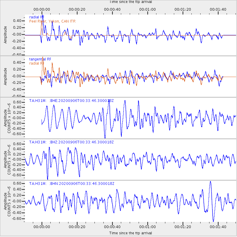
H31M Peel River, Yukon, CAN - Earthquake Result Viewer
*The percent match for this event was below the threshold and hence no stack was calculated.
| Earthquake location: |
Northern Molucca Sea |
| Earthquake latitude/longitude: |
1.7/126.6 |
| Earthquake time(UTC): |
2020/09/06 (250) 00:21:10 GMT |
| Earthquake Depth: |
30 km |
| Earthquake Magnitude: |
5.9 Mww |
| Earthquake Catalog/Contributor: |
NEIC PDE/us |
|
| Network: |
TA USArray Transportable Network (new EarthScope stations) |
| Station: |
H31M Peel River, Yukon, CAN |
| Lat/Lon: |
65.81 N/134.34 W |
| Elevation: |
642 m |
|
| Distance: |
92.2 deg |
| Az: |
24.033 deg |
| Baz: |
278.976 deg |
| Ray Param: |
$rayparam |
*The percent match for this event was below the threshold and hence was not used in the summary stack. |
|
| Radial Match: |
73.302086 % |
| Radial Bump: |
400 |
| Transverse Match: |
51.734955 % |
| Transverse Bump: |
400 |
| SOD ConfigId: |
22732711 |
| Insert Time: |
2020-09-20 00:33:24.022 +0000 |
| GWidth: |
2.5 |
| Max Bumps: |
400 |
| Tol: |
0.001 |
|
Signal To Noise
| Channel | StoN | STA | LTA |
| TA:H31M: :BHZ:20200906T00:33:46.300018Z | 1.4756902 | 3.177627E-7 | 2.1533158E-7 |
| TA:H31M: :BHN:20200906T00:33:46.300018Z | 0.85211945 | 1.721219E-7 | 2.019927E-7 |
| TA:H31M: :BHE:20200906T00:33:46.300018Z | 0.6981052 | 1.811657E-7 | 2.5951059E-7 |
| Arrivals |
| Ps | |
| PpPs | |
| PsPs/PpSs | |


