You are here: Home > Network List > TA - USArray Transportable Network (new EarthScope stations) Stations List
> Station K13K Kusilvak Mountain, AK, USA > Earthquake Result Viewer
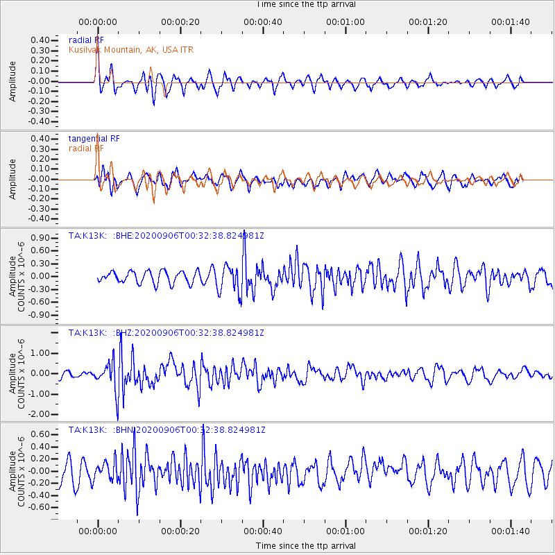
K13K Kusilvak Mountain, AK, USA - Earthquake Result Viewer
*The percent match for this event was below the threshold and hence no stack was calculated.
| Earthquake location: |
Northern Molucca Sea |
| Earthquake latitude/longitude: |
1.7/126.6 |
| Earthquake time(UTC): |
2020/09/06 (250) 00:21:10 GMT |
| Earthquake Depth: |
30 km |
| Earthquake Magnitude: |
5.9 Mww |
| Earthquake Catalog/Contributor: |
NEIC PDE/us |
|
| Network: |
TA USArray Transportable Network (new EarthScope stations) |
| Station: |
K13K Kusilvak Mountain, AK, USA |
| Lat/Lon: |
61.93 N/164.66 W |
| Elevation: |
204 m |
|
| Distance: |
78.7 deg |
| Az: |
26.723 deg |
| Baz: |
251.873 deg |
| Ray Param: |
$rayparam |
*The percent match for this event was below the threshold and hence was not used in the summary stack. |
|
| Radial Match: |
67.57034 % |
| Radial Bump: |
372 |
| Transverse Match: |
61.83543 % |
| Transverse Bump: |
400 |
| SOD ConfigId: |
22732711 |
| Insert Time: |
2020-09-20 00:33:35.972 +0000 |
| GWidth: |
2.5 |
| Max Bumps: |
400 |
| Tol: |
0.001 |
|
Signal To Noise
| Channel | StoN | STA | LTA |
| TA:K13K: :BHZ:20200906T00:32:38.824981Z | 3.974366 | 7.3346087E-7 | 1.845479E-7 |
| TA:K13K: :BHN:20200906T00:32:38.824981Z | 0.90387285 | 1.4558861E-7 | 1.61072E-7 |
| TA:K13K: :BHE:20200906T00:32:38.824981Z | 2.3925881 | 3.277693E-7 | 1.3699362E-7 |
| Arrivals |
| Ps | |
| PpPs | |
| PsPs/PpSs | |


