You are here: Home > Network List > C0 - Colorado Geological Survey Seismic Network Stations List
> Station HAYD Hayden Colorado > Earthquake Result Viewer
HAYD Hayden Colorado - Earthquake Result Viewer
| Earthquake location: |
Near Coast Of Central Chile |
| Earthquake latitude/longitude: |
-30.3/-71.6 |
| Earthquake time(UTC): |
2020/09/06 (250) 01:16:58 GMT |
| Earthquake Depth: |
31 km |
| Earthquake Magnitude: |
6.3 Mww |
| Earthquake Catalog/Contributor: |
NEIC PDE/us |
|
| Network: |
C0 Colorado Geological Survey Seismic Network |
| Station: |
HAYD Hayden Colorado |
| Lat/Lon: |
40.53 N/107.27 W |
| Elevation: |
2202 m |
|
| Distance: |
77.9 deg |
| Az: |
332.939 deg |
| Baz: |
148.935 deg |
| Ray Param: |
0.049987763 |
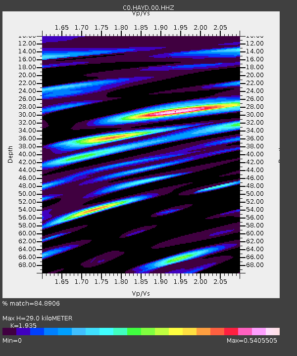
| Estimated Moho Depth: |
29.0 km |
| Estimated Crust Vp/Vs: |
1.93 |
| Assumed Crust Vp: |
6.159 km/s |
| Estimated Crust Vs: |
3.183 km/s |
| Estimated Crust Poisson's Ratio: |
0.32 |
|
| Radial Match: |
84.8906 % |
| Radial Bump: |
400 |
| Transverse Match: |
84.890625 % |
| Transverse Bump: |
400 |
| SOD ConfigId: |
22732711 |
| Insert Time: |
2020-09-20 01:19:41.868 +0000 |
| GWidth: |
2.5 |
| Max Bumps: |
400 |
| Tol: |
0.001 |
|

Signal To Noise
| Channel | StoN | STA | LTA |
| C0:HAYD:00:HHZ:20200906T01:28:22.549019Z | 5.013526 | 4.92608E-7 | 9.82558E-8 |
| $trig.getChannelId() | $trig.getValue() | $trig.getSTA() | $trig.getLTA() |
| C0:HAYD:00:HHE:20200906T01:28:22.549019Z | 1.7433407 | 1.452829E-7 | 8.333592E-8 |
| Arrivals |
| Ps | 4.5 SECOND |
| PpPs | 13 SECOND |
| PsPs/PpSs | 18 SECOND |


