You are here: Home > Network List > US - United States National Seismic Network Stations List
> Station WMOK Wichita Mountains, Oklahoma, USA > Earthquake Result Viewer
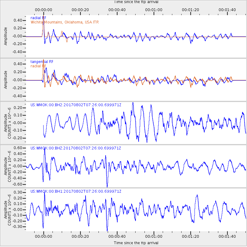
WMOK Wichita Mountains, Oklahoma, USA - Earthquake Result Viewer
*The percent match for this event was below the threshold and hence no stack was calculated.
| Earthquake location: |
Chile-Argentina Border Region |
| Earthquake latitude/longitude: |
-33.2/-70.6 |
| Earthquake time(UTC): |
2017/08/02 (214) 07:15:13 GMT |
| Earthquake Depth: |
88 km |
| Earthquake Magnitude: |
5.5 Mww |
| Earthquake Catalog/Contributor: |
NEIC PDE/us |
|
| Network: |
US United States National Seismic Network |
| Station: |
WMOK Wichita Mountains, Oklahoma, USA |
| Lat/Lon: |
34.74 N/98.78 W |
| Elevation: |
486 m |
|
| Distance: |
72.6 deg |
| Az: |
335.972 deg |
| Baz: |
155.512 deg |
| Ray Param: |
$rayparam |
*The percent match for this event was below the threshold and hence was not used in the summary stack. |
|
| Radial Match: |
69.93789 % |
| Radial Bump: |
400 |
| Transverse Match: |
57.04395 % |
| Transverse Bump: |
395 |
| SOD ConfigId: |
2140511 |
| Insert Time: |
2017-08-15 23:11:59.917 +0000 |
| GWidth: |
2.5 |
| Max Bumps: |
400 |
| Tol: |
0.001 |
|
Signal To Noise
| Channel | StoN | STA | LTA |
| US:WMOK:00:BHZ:20170802T07:26:00.699971Z | 3.6970274 | 2.884948E-7 | 7.8034255E-8 |
| US:WMOK:00:BH1:20170802T07:26:00.699971Z | 1.260303 | 1.30118E-7 | 1.0324342E-7 |
| US:WMOK:00:BH2:20170802T07:26:00.699971Z | 0.9521416 | 7.709429E-8 | 8.096936E-8 |
| Arrivals |
| Ps | |
| PpPs | |
| PsPs/PpSs | |


