You are here: Home > Network List > CI - Caltech Regional Seismic Network Stations List
> Station TIN Tinemaha, Big Pine, CA, USA > Earthquake Result Viewer
TIN Tinemaha, Big Pine, CA, USA - Earthquake Result Viewer

| Earthquake location: |
Near Coast Of Central Chile |
| Earthquake latitude/longitude: |
-30.3/-71.6 |
| Earthquake time(UTC): |
2020/09/06 (250) 01:16:58 GMT |
| Earthquake Depth: |
31 km |
| Earthquake Magnitude: |
6.3 Mww |
| Earthquake Catalog/Contributor: |
NEIC PDE/us |
|
| Network: |
CI Caltech Regional Seismic Network |
| Station: |
TIN Tinemaha, Big Pine, CA, USA |
| Lat/Lon: |
37.05 N/118.23 W |
| Elevation: |
1197 m |
|
| Distance: |
80.0 deg |
| Az: |
323.785 deg |
| Baz: |
140.321 deg |
| Ray Param: |
0.048522078 |
| Estimated Moho Depth: |
37.5 km |
| Estimated Crust Vp/Vs: |
1.80 |
| Assumed Crust Vp: |
6.291 km/s |
| Estimated Crust Vs: |
3.495 km/s |
| Estimated Crust Poisson's Ratio: |
0.28 |
|
| Radial Match: |
92.918884 % |
| Radial Bump: |
400 |
| Transverse Match: |
81.88734 % |
| Transverse Bump: |
400 |
| SOD ConfigId: |
22732711 |
| Insert Time: |
2020-09-20 01:22:16.694 +0000 |
| GWidth: |
2.5 |
| Max Bumps: |
400 |
| Tol: |
0.001 |
|
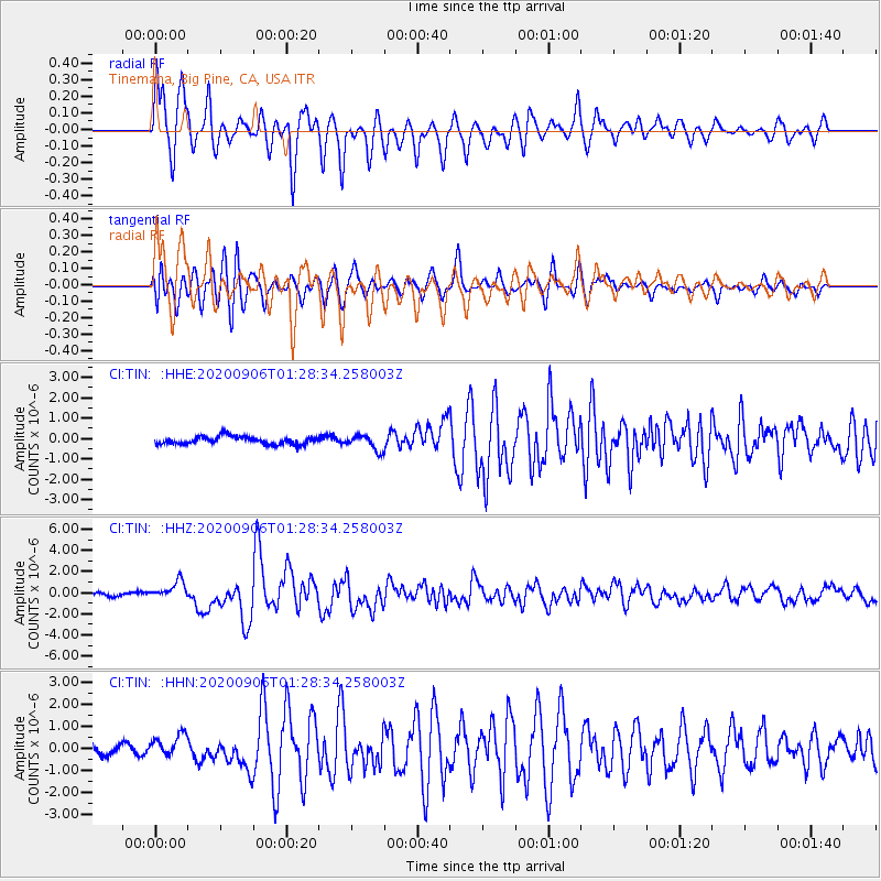
Signal To Noise
| Channel | StoN | STA | LTA |
| CI:TIN: :HHZ:20200906T01:28:34.258003Z | 5.0281587 | 8.407723E-7 | 1.6721276E-7 |
| CI:TIN: :HHN:20200906T01:28:34.258003Z | 3.0839775 | 5.0146053E-7 | 1.6260188E-7 |
| CI:TIN: :HHE:20200906T01:28:34.258003Z | 1.9646437 | 3.7550384E-7 | 1.9113077E-7 |
| Arrivals |
| Ps | 4.9 SECOND |
| PpPs | 16 SECOND |
| PsPs/PpSs | 21 SECOND |


