You are here: Home > Network List > CN - Canadian National Seismograph Network Stations List
> Station HSNB Heath Steele Mine, NB, CA > Earthquake Result Viewer
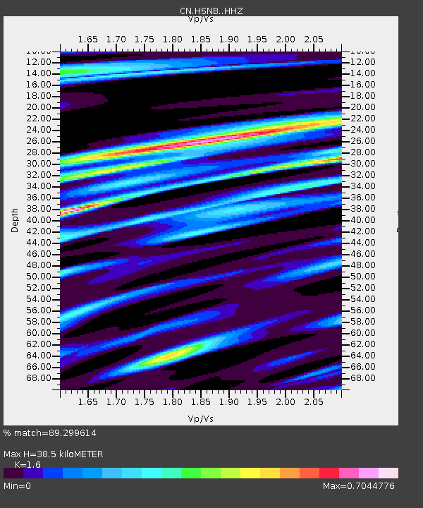
HSNB Heath Steele Mine, NB, CA - Earthquake Result Viewer
| Earthquake location: |
Near Coast Of Central Chile |
| Earthquake latitude/longitude: |
-30.3/-71.6 |
| Earthquake time(UTC): |
2020/09/06 (250) 01:16:58 GMT |
| Earthquake Depth: |
31 km |
| Earthquake Magnitude: |
6.3 Mww |
| Earthquake Catalog/Contributor: |
NEIC PDE/us |
|
| Network: |
CN Canadian National Seismograph Network |
| Station: |
HSNB Heath Steele Mine, NB, CA |
| Lat/Lon: |
47.28 N/66.06 W |
| Elevation: |
337 m |
|
| Distance: |
77.4 deg |
| Az: |
3.837 deg |
| Baz: |
184.874 deg |
| Ray Param: |
0.050304487 |
| Estimated Moho Depth: |
38.5 km |
| Estimated Crust Vp/Vs: |
1.60 |
| Assumed Crust Vp: |
6.419 km/s |
| Estimated Crust Vs: |
4.012 km/s |
| Estimated Crust Poisson's Ratio: |
0.18 |
|
| Radial Match: |
89.299614 % |
| Radial Bump: |
400 |
| Transverse Match: |
77.06084 % |
| Transverse Bump: |
400 |
| SOD ConfigId: |
22732711 |
| Insert Time: |
2020-09-20 01:23:16.821 +0000 |
| GWidth: |
2.5 |
| Max Bumps: |
400 |
| Tol: |
0.001 |
|

Signal To Noise
| Channel | StoN | STA | LTA |
| CN:HSNB: :HHZ:20200906T01:28:19.91999Z | 4.5040913 | 1.3899655E-6 | 3.0860065E-7 |
| CN:HSNB: :HHN:20200906T01:28:19.91999Z | 3.4459937 | 5.8941106E-7 | 1.710424E-7 |
| CN:HSNB: :HHE:20200906T01:28:19.91999Z | 1.6650109 | 2.9546123E-7 | 1.7745303E-7 |
| Arrivals |
| Ps | 3.7 SECOND |
| PpPs | 15 SECOND |
| PsPs/PpSs | 19 SECOND |


