You are here: Home > Network List > XB96 - Abitibi Experiment Stations List
> Station BELL Bellecombe > Earthquake Result Viewer
BELL Bellecombe - Earthquake Result Viewer
| Earthquake location: |
Guerrero, Mexico |
| Earthquake latitude/longitude: |
17.6/-101.0 |
| Earthquake time(UTC): |
1996/07/15 (197) 21:23:34 GMT |
| Earthquake Depth: |
18 km |
| Earthquake Magnitude: |
5.7 MB, 6.5 MS, 6.6 UNKNOWN, 6.2 ME |
| Earthquake Catalog/Contributor: |
WHDF/NEIC |
|
| Network: |
XB Abitibi Experiment |
| Station: |
BELL Bellecombe |
| Lat/Lon: |
48.10 N/78.94 W |
| Elevation: |
282 m |
|
| Distance: |
35.3 deg |
| Az: |
25.757 deg |
| Baz: |
218.19 deg |
| Ray Param: |
0.077255934 |
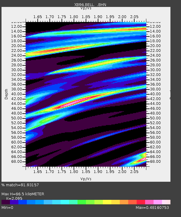
| Estimated Moho Depth: |
66.5 km |
| Estimated Crust Vp/Vs: |
2.10 |
| Assumed Crust Vp: |
6.61 km/s |
| Estimated Crust Vs: |
3.155 km/s |
| Estimated Crust Poisson's Ratio: |
0.35 |
|
| Radial Match: |
91.93157 % |
| Radial Bump: |
269 |
| Transverse Match: |
66.352036 % |
| Transverse Bump: |
400 |
| SOD ConfigId: |
6273 |
| Insert Time: |
2010-03-09 00:51:16.943 +0000 |
| GWidth: |
2.5 |
| Max Bumps: |
400 |
| Tol: |
0.001 |
|

Signal To Noise
| Channel | StoN | STA | LTA |
| XB:BELL: :BHN:19960715T21:29:57.522003Z | 5.427192 | 9.814274E-7 | 1.808352E-7 |
| XB:BELL: :BHE:19960715T21:29:57.522003Z | 7.4481654 | 8.3848323E-7 | 1.1257581E-7 |
| XB:BELL: :BHZ:19960715T21:29:57.522003Z | 10.078717 | 1.914338E-6 | 1.8993866E-7 |
| Arrivals |
| Ps | 12 SECOND |
| PpPs | 29 SECOND |
| PsPs/PpSs | 41 SECOND |


