You are here: Home > Network List > N4 - Central and EAstern US Network Stations List
> Station O49A Covington, OH, USA > Earthquake Result Viewer
O49A Covington, OH, USA - Earthquake Result Viewer
| Earthquake location: |
Near Coast Of Central Chile |
| Earthquake latitude/longitude: |
-30.3/-71.6 |
| Earthquake time(UTC): |
2020/09/06 (250) 01:16:58 GMT |
| Earthquake Depth: |
31 km |
| Earthquake Magnitude: |
6.3 Mww |
| Earthquake Catalog/Contributor: |
NEIC PDE/us |
|
| Network: |
N4 Central and EAstern US Network |
| Station: |
O49A Covington, OH, USA |
| Lat/Lon: |
40.19 N/84.34 W |
| Elevation: |
292 m |
|
| Distance: |
71.2 deg |
| Az: |
349.693 deg |
| Baz: |
168.35 deg |
| Ray Param: |
0.054466758 |
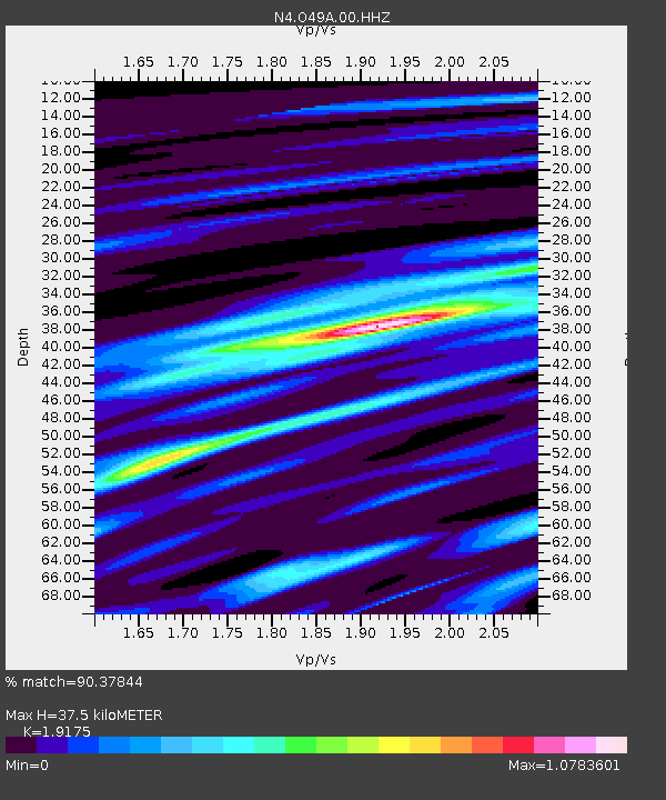
| Estimated Moho Depth: |
37.5 km |
| Estimated Crust Vp/Vs: |
1.92 |
| Assumed Crust Vp: |
6.498 km/s |
| Estimated Crust Vs: |
3.389 km/s |
| Estimated Crust Poisson's Ratio: |
0.31 |
|
| Radial Match: |
90.37844 % |
| Radial Bump: |
398 |
| Transverse Match: |
60.915882 % |
| Transverse Bump: |
400 |
| SOD ConfigId: |
22732711 |
| Insert Time: |
2020-09-20 01:30:41.801 +0000 |
| GWidth: |
2.5 |
| Max Bumps: |
400 |
| Tol: |
0.001 |
|

Signal To Noise
| Channel | StoN | STA | LTA |
| N4:O49A:00:HHZ:20200906T01:27:43.630012Z | 10.067717 | 1.7312016E-6 | 1.7195573E-7 |
| N4:O49A:00:HH1:20200906T01:27:43.630012Z | 3.8415697 | 5.944879E-7 | 1.547513E-7 |
| N4:O49A:00:HH2:20200906T01:27:43.630012Z | 1.2704785 | 2.686307E-7 | 2.1144058E-7 |
| Arrivals |
| Ps | 5.5 SECOND |
| PpPs | 16 SECOND |
| PsPs/PpSs | 22 SECOND |


