You are here: Home > Network List > N4 - Central and EAstern US Network Stations List
> Station S39B Bolivar, MO, USA > Earthquake Result Viewer
S39B Bolivar, MO, USA - Earthquake Result Viewer
| Earthquake location: |
Near Coast Of Central Chile |
| Earthquake latitude/longitude: |
-30.3/-71.6 |
| Earthquake time(UTC): |
2020/09/06 (250) 01:16:58 GMT |
| Earthquake Depth: |
31 km |
| Earthquake Magnitude: |
6.3 Mww |
| Earthquake Catalog/Contributor: |
NEIC PDE/us |
|
| Network: |
N4 Central and EAstern US Network |
| Station: |
S39B Bolivar, MO, USA |
| Lat/Lon: |
37.69 N/93.32 W |
| Elevation: |
340 m |
|
| Distance: |
70.7 deg |
| Az: |
341.842 deg |
| Baz: |
160.145 deg |
| Ray Param: |
0.054797016 |
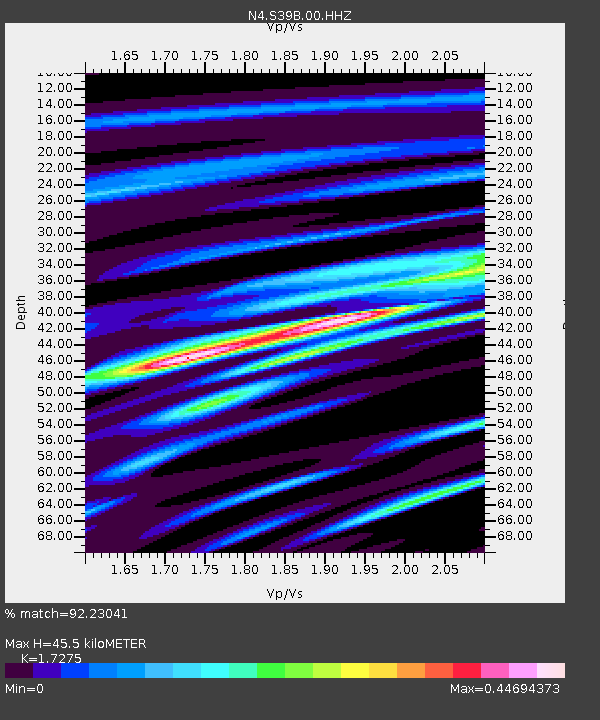
| Estimated Moho Depth: |
45.5 km |
| Estimated Crust Vp/Vs: |
1.73 |
| Assumed Crust Vp: |
6.53 km/s |
| Estimated Crust Vs: |
3.78 km/s |
| Estimated Crust Poisson's Ratio: |
0.25 |
|
| Radial Match: |
92.23041 % |
| Radial Bump: |
314 |
| Transverse Match: |
73.04718 % |
| Transverse Bump: |
400 |
| SOD ConfigId: |
22732711 |
| Insert Time: |
2020-09-20 01:31:12.987 +0000 |
| GWidth: |
2.5 |
| Max Bumps: |
400 |
| Tol: |
0.001 |
|

Signal To Noise
| Channel | StoN | STA | LTA |
| N4:S39B:00:HHZ:20200906T01:27:40.649971Z | 8.434064 | 1.3644872E-6 | 1.6178289E-7 |
| N4:S39B:00:HH1:20200906T01:27:40.649971Z | 4.3100395 | 5.0685463E-7 | 1.175986E-7 |
| N4:S39B:00:HH2:20200906T01:27:40.649971Z | 1.0651507 | 1.3744142E-7 | 1.290347E-7 |
| Arrivals |
| Ps | 5.3 SECOND |
| PpPs | 18 SECOND |
| PsPs/PpSs | 24 SECOND |


