You are here: Home > Network List > N4 - Central and EAstern US Network Stations List
> Station Z38B Mount Pleasant, TX, USA > Earthquake Result Viewer
Z38B Mount Pleasant, TX, USA - Earthquake Result Viewer
| Earthquake location: |
Near Coast Of Central Chile |
| Earthquake latitude/longitude: |
-30.3/-71.6 |
| Earthquake time(UTC): |
2020/09/06 (250) 01:16:58 GMT |
| Earthquake Depth: |
31 km |
| Earthquake Magnitude: |
6.3 Mww |
| Earthquake Catalog/Contributor: |
NEIC PDE/us |
|
| Network: |
N4 Central and EAstern US Network |
| Station: |
Z38B Mount Pleasant, TX, USA |
| Lat/Lon: |
33.26 N/94.99 W |
| Elevation: |
115 m |
|
| Distance: |
67.0 deg |
| Az: |
338.793 deg |
| Baz: |
158.083 deg |
| Ray Param: |
0.057182323 |
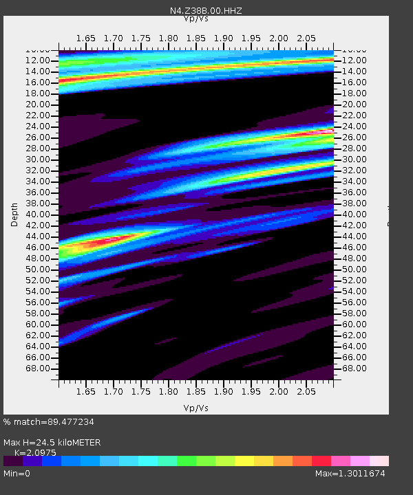
| Estimated Moho Depth: |
24.5 km |
| Estimated Crust Vp/Vs: |
2.10 |
| Assumed Crust Vp: |
6.245 km/s |
| Estimated Crust Vs: |
2.977 km/s |
| Estimated Crust Poisson's Ratio: |
0.35 |
|
| Radial Match: |
89.477234 % |
| Radial Bump: |
400 |
| Transverse Match: |
69.35586 % |
| Transverse Bump: |
400 |
| SOD ConfigId: |
22732711 |
| Insert Time: |
2020-09-20 01:32:04.063 +0000 |
| GWidth: |
2.5 |
| Max Bumps: |
400 |
| Tol: |
0.001 |
|

Signal To Noise
| Channel | StoN | STA | LTA |
| N4:Z38B:00:HHZ:20200906T01:27:18.018989Z | 8.268802 | 1.3030145E-6 | 1.5758204E-7 |
| N4:Z38B:00:HH1:20200906T01:27:18.018989Z | 1.5077224 | 3.8819564E-7 | 2.5747156E-7 |
| N4:Z38B:00:HH2:20200906T01:27:18.018989Z | 0.7329944 | 3.2439857E-7 | 4.4256626E-7 |
| Arrivals |
| Ps | 4.4 SECOND |
| PpPs | 12 SECOND |
| PsPs/PpSs | 16 SECOND |


