You are here: Home > Network List > NE - New England Seismic Network Stations List
> Station HNH Hanover, NH, USA > Earthquake Result Viewer
HNH Hanover, NH, USA - Earthquake Result Viewer
| Earthquake location: |
Near Coast Of Central Chile |
| Earthquake latitude/longitude: |
-30.3/-71.6 |
| Earthquake time(UTC): |
2020/09/06 (250) 01:16:58 GMT |
| Earthquake Depth: |
31 km |
| Earthquake Magnitude: |
6.3 Mww |
| Earthquake Catalog/Contributor: |
NEIC PDE/us |
|
| Network: |
NE New England Seismic Network |
| Station: |
HNH Hanover, NH, USA |
| Lat/Lon: |
43.71 N/72.29 W |
| Elevation: |
180 m |
|
| Distance: |
73.7 deg |
| Az: |
359.454 deg |
| Baz: |
179.349 deg |
| Ray Param: |
0.05280255 |
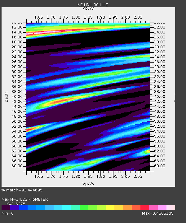
| Estimated Moho Depth: |
14.25 km |
| Estimated Crust Vp/Vs: |
1.63 |
| Assumed Crust Vp: |
6.419 km/s |
| Estimated Crust Vs: |
3.944 km/s |
| Estimated Crust Poisson's Ratio: |
0.20 |
|
| Radial Match: |
93.444695 % |
| Radial Bump: |
400 |
| Transverse Match: |
78.655045 % |
| Transverse Bump: |
400 |
| SOD ConfigId: |
22732711 |
| Insert Time: |
2020-09-20 01:32:11.661 +0000 |
| GWidth: |
2.5 |
| Max Bumps: |
400 |
| Tol: |
0.001 |
|

Signal To Noise
| Channel | StoN | STA | LTA |
| NE:HNH:00:HHZ:20200906T01:27:58.62397Z | 9.446302 | 1.3666136E-6 | 1.446718E-7 |
| NE:HNH:00:HH1:20200906T01:27:58.62397Z | 4.2505884 | 5.7088306E-7 | 1.3430683E-7 |
| NE:HNH:00:HH2:20200906T01:27:58.62397Z | 1.124132 | 1.9471726E-7 | 1.7321565E-7 |
| Arrivals |
| Ps | 1.4 SECOND |
| PpPs | 5.6 SECOND |
| PsPs/PpSs | 7.1 SECOND |


