You are here: Home > Network List > NE - New England Seismic Network Stations List
> Station WSPT Westport, CT, USA > Earthquake Result Viewer
WSPT Westport, CT, USA - Earthquake Result Viewer
| Earthquake location: |
Near Coast Of Central Chile |
| Earthquake latitude/longitude: |
-30.3/-71.6 |
| Earthquake time(UTC): |
2020/09/06 (250) 01:16:58 GMT |
| Earthquake Depth: |
31 km |
| Earthquake Magnitude: |
6.3 Mww |
| Earthquake Catalog/Contributor: |
NEIC PDE/us |
|
| Network: |
NE New England Seismic Network |
| Station: |
WSPT Westport, CT, USA |
| Lat/Lon: |
41.17 N/73.33 W |
| Elevation: |
91 m |
|
| Distance: |
71.2 deg |
| Az: |
358.593 deg |
| Baz: |
178.389 deg |
| Ray Param: |
0.054462984 |
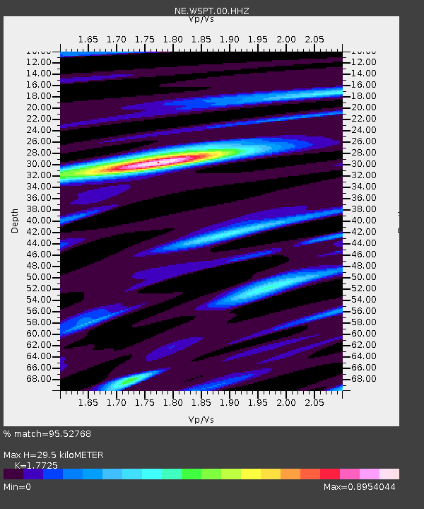
| Estimated Moho Depth: |
29.5 km |
| Estimated Crust Vp/Vs: |
1.77 |
| Assumed Crust Vp: |
6.472 km/s |
| Estimated Crust Vs: |
3.651 km/s |
| Estimated Crust Poisson's Ratio: |
0.27 |
|
| Radial Match: |
95.52768 % |
| Radial Bump: |
337 |
| Transverse Match: |
82.1931 % |
| Transverse Bump: |
400 |
| SOD ConfigId: |
22732711 |
| Insert Time: |
2020-09-20 01:32:17.803 +0000 |
| GWidth: |
2.5 |
| Max Bumps: |
400 |
| Tol: |
0.001 |
|

Signal To Noise
| Channel | StoN | STA | LTA |
| NE:WSPT:00:HHZ:20200906T01:27:43.669014Z | 10.6234 | 1.4728253E-6 | 1.3863973E-7 |
| NE:WSPT:00:HH1:20200906T01:27:43.669014Z | 3.9098845 | 5.8785486E-7 | 1.5035096E-7 |
| NE:WSPT:00:HH2:20200906T01:27:43.669014Z | 1.8862582 | 1.998955E-7 | 1.05974614E-7 |
| Arrivals |
| Ps | 3.7 SECOND |
| PpPs | 12 SECOND |
| PsPs/PpSs | 16 SECOND |


