You are here: Home > Network List > O2 - Oklahoma Consolidated Temporary Seismic Networks Stations List
> Station SC07 Cyril, Oklahoma, USA > Earthquake Result Viewer
SC07 Cyril, Oklahoma, USA - Earthquake Result Viewer
| Earthquake location: |
Near Coast Of Central Chile |
| Earthquake latitude/longitude: |
-30.3/-71.6 |
| Earthquake time(UTC): |
2020/09/06 (250) 01:16:58 GMT |
| Earthquake Depth: |
31 km |
| Earthquake Magnitude: |
6.3 Mww |
| Earthquake Catalog/Contributor: |
NEIC PDE/us |
|
| Network: |
O2 Oklahoma Consolidated Temporary Seismic Networks |
| Station: |
SC07 Cyril, Oklahoma, USA |
| Lat/Lon: |
34.93 N/98.21 W |
| Elevation: |
349 m |
|
| Distance: |
69.6 deg |
| Az: |
336.849 deg |
| Baz: |
155.562 deg |
| Ray Param: |
0.055488735 |
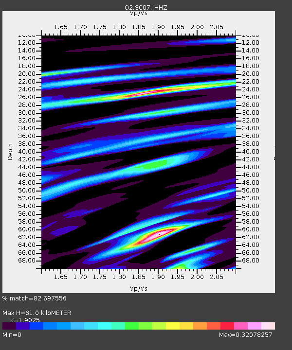
| Estimated Moho Depth: |
61.0 km |
| Estimated Crust Vp/Vs: |
1.90 |
| Assumed Crust Vp: |
6.315 km/s |
| Estimated Crust Vs: |
3.319 km/s |
| Estimated Crust Poisson's Ratio: |
0.31 |
|
| Radial Match: |
82.697556 % |
| Radial Bump: |
364 |
| Transverse Match: |
82.69755 % |
| Transverse Bump: |
364 |
| SOD ConfigId: |
22732711 |
| Insert Time: |
2020-09-20 01:34:55.278 +0000 |
| GWidth: |
2.5 |
| Max Bumps: |
400 |
| Tol: |
0.001 |
|

Signal To Noise
| Channel | StoN | STA | LTA |
| O2:SC07: :HHZ:20200906T01:27:34.185005Z | 4.79872 | 2.0002242E-6 | 4.1682458E-7 |
| $trig.getChannelId() | $trig.getValue() | $trig.getSTA() | $trig.getLTA() |
| O2:SC07: :HHE:20200906T01:27:34.185005Z | 2.5336163 | 1.0213449E-6 | 4.031174E-7 |
| Arrivals |
| Ps | 9.0 SECOND |
| PpPs | 27 SECOND |
| PsPs/PpSs | 36 SECOND |


