You are here: Home > Network List > TX - Texas Seismological Network Stations List
> Station WTFS Witchita Falls > Earthquake Result Viewer
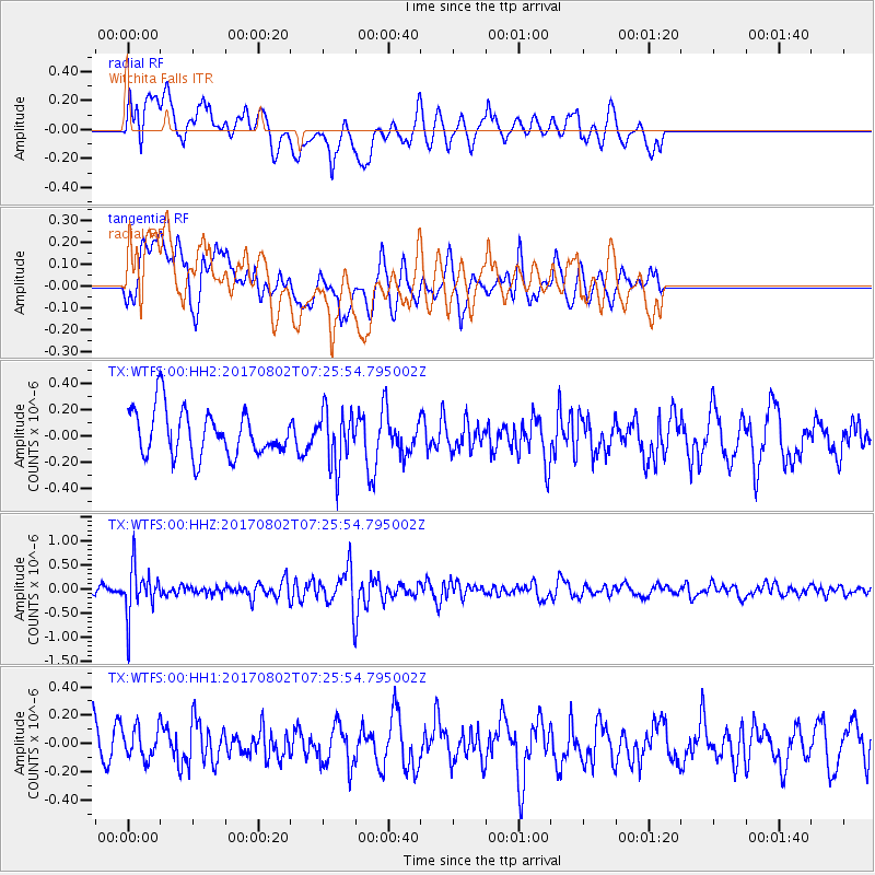
WTFS Witchita Falls - Earthquake Result Viewer
*The percent match for this event was below the threshold and hence no stack was calculated.
| Earthquake location: |
Chile-Argentina Border Region |
| Earthquake latitude/longitude: |
-33.2/-70.6 |
| Earthquake time(UTC): |
2017/08/02 (214) 07:15:13 GMT |
| Earthquake Depth: |
88 km |
| Earthquake Magnitude: |
5.5 Mww |
| Earthquake Catalog/Contributor: |
NEIC PDE/us |
|
| Network: |
TX Texas Seismological Network |
| Station: |
WTFS Witchita Falls |
| Lat/Lon: |
33.77 N/98.46 W |
| Elevation: |
277 m |
|
| Distance: |
71.6 deg |
| Az: |
335.802 deg |
| Baz: |
155.637 deg |
| Ray Param: |
$rayparam |
*The percent match for this event was below the threshold and hence was not used in the summary stack. |
|
| Radial Match: |
62.51016 % |
| Radial Bump: |
400 |
| Transverse Match: |
44.871735 % |
| Transverse Bump: |
400 |
| SOD ConfigId: |
2140511 |
| Insert Time: |
2017-08-15 23:13:51.315 +0000 |
| GWidth: |
2.5 |
| Max Bumps: |
400 |
| Tol: |
0.001 |
|
Signal To Noise
| Channel | StoN | STA | LTA |
| TX:WTFS:00:HHZ:20170802T07:25:54.795002Z | 4.8419023 | 5.009917E-7 | 1.03470015E-7 |
| TX:WTFS:00:HH1:20170802T07:25:54.795002Z | 0.7170126 | 1.1183548E-7 | 1.5597423E-7 |
| TX:WTFS:00:HH2:20170802T07:25:54.795002Z | 1.2295111 | 2.1261997E-7 | 1.7293048E-7 |
| Arrivals |
| Ps | |
| PpPs | |
| PsPs/PpSs | |


