You are here: Home > Network List > O2 - Oklahoma Consolidated Temporary Seismic Networks Stations List
> Station SHWN Shawnee, Oklahoma, USA > Earthquake Result Viewer
SHWN Shawnee, Oklahoma, USA - Earthquake Result Viewer
| Earthquake location: |
Near Coast Of Central Chile |
| Earthquake latitude/longitude: |
-30.3/-71.6 |
| Earthquake time(UTC): |
2020/09/06 (250) 01:16:58 GMT |
| Earthquake Depth: |
31 km |
| Earthquake Magnitude: |
6.3 Mww |
| Earthquake Catalog/Contributor: |
NEIC PDE/us |
|
| Network: |
O2 Oklahoma Consolidated Temporary Seismic Networks |
| Station: |
SHWN Shawnee, Oklahoma, USA |
| Lat/Lon: |
35.34 N/97.02 W |
| Elevation: |
320 m |
|
| Distance: |
69.6 deg |
| Az: |
337.978 deg |
| Baz: |
156.638 deg |
| Ray Param: |
0.055503786 |
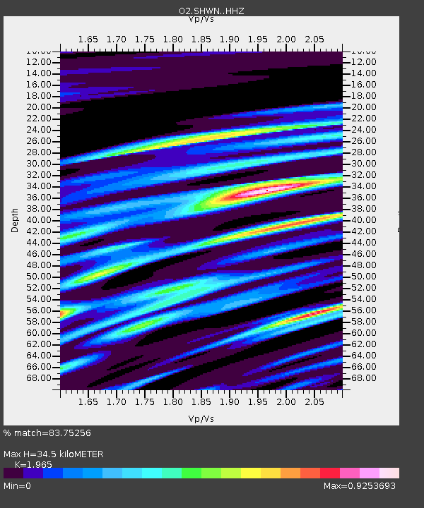
| Estimated Moho Depth: |
34.5 km |
| Estimated Crust Vp/Vs: |
1.97 |
| Assumed Crust Vp: |
6.426 km/s |
| Estimated Crust Vs: |
3.27 km/s |
| Estimated Crust Poisson's Ratio: |
0.33 |
|
| Radial Match: |
83.75256 % |
| Radial Bump: |
400 |
| Transverse Match: |
70.41956 % |
| Transverse Bump: |
400 |
| SOD ConfigId: |
22732711 |
| Insert Time: |
2020-09-20 01:35:12.402 +0000 |
| GWidth: |
2.5 |
| Max Bumps: |
400 |
| Tol: |
0.001 |
|

Signal To Noise
| Channel | StoN | STA | LTA |
| O2:SHWN: :HHZ:20200906T01:27:34.039985Z | 7.320436 | 9.307193E-7 | 1.2713987E-7 |
| O2:SHWN: :HHN:20200906T01:27:34.039985Z | 3.2014918 | 4.527107E-7 | 1.4140618E-7 |
| O2:SHWN: :HHE:20200906T01:27:34.039985Z | 1.1997828 | 2.9496806E-7 | 2.458512E-7 |
| Arrivals |
| Ps | 5.4 SECOND |
| PpPs | 15 SECOND |
| PsPs/PpSs | 21 SECOND |


