You are here: Home > Network List > PE - Penn State Network Stations List
> Station PAMP Mt. Pisgah State Park, Troy, PA > Earthquake Result Viewer
PAMP Mt. Pisgah State Park, Troy, PA - Earthquake Result Viewer
| Earthquake location: |
Near Coast Of Central Chile |
| Earthquake latitude/longitude: |
-30.3/-71.6 |
| Earthquake time(UTC): |
2020/09/06 (250) 01:16:58 GMT |
| Earthquake Depth: |
31 km |
| Earthquake Magnitude: |
6.3 Mww |
| Earthquake Catalog/Contributor: |
NEIC PDE/us |
|
| Network: |
PE Penn State Network |
| Station: |
PAMP Mt. Pisgah State Park, Troy, PA |
| Lat/Lon: |
41.81 N/76.67 W |
| Elevation: |
348 m |
|
| Distance: |
71.9 deg |
| Az: |
355.988 deg |
| Baz: |
175.359 deg |
| Ray Param: |
0.053959724 |
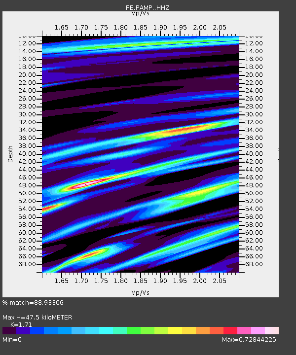
| Estimated Moho Depth: |
47.5 km |
| Estimated Crust Vp/Vs: |
1.71 |
| Assumed Crust Vp: |
6.121 km/s |
| Estimated Crust Vs: |
3.579 km/s |
| Estimated Crust Poisson's Ratio: |
0.24 |
|
| Radial Match: |
88.93306 % |
| Radial Bump: |
400 |
| Transverse Match: |
68.480194 % |
| Transverse Bump: |
400 |
| SOD ConfigId: |
22732711 |
| Insert Time: |
2020-09-20 01:36:45.499 +0000 |
| GWidth: |
2.5 |
| Max Bumps: |
400 |
| Tol: |
0.001 |
|

Signal To Noise
| Channel | StoN | STA | LTA |
| PE:PAMP: :HHZ:20200906T01:27:48.28498Z | 4.745173 | 1.3526476E-6 | 2.8505758E-7 |
| PE:PAMP: :HHN:20200906T01:27:48.28498Z | 5.0818796 | 6.8377415E-7 | 1.3455143E-7 |
| PE:PAMP: :HHE:20200906T01:27:48.28498Z | 1.5472088 | 3.540178E-7 | 2.2881062E-7 |
| Arrivals |
| Ps | 5.7 SECOND |
| PpPs | 20 SECOND |
| PsPs/PpSs | 26 SECOND |


