You are here: Home > Network List > UU - University of Utah Regional Network Stations List
> Station BRWY Blue Rim, WY, USA > Earthquake Result Viewer
BRWY Blue Rim, WY, USA - Earthquake Result Viewer
| Earthquake location: |
Near Coast Of Central Chile |
| Earthquake latitude/longitude: |
-30.3/-71.6 |
| Earthquake time(UTC): |
2020/09/06 (250) 01:16:58 GMT |
| Earthquake Depth: |
31 km |
| Earthquake Magnitude: |
6.3 Mww |
| Earthquake Catalog/Contributor: |
NEIC PDE/us |
|
| Network: |
UU University of Utah Regional Network |
| Station: |
BRWY Blue Rim, WY, USA |
| Lat/Lon: |
41.62 N/109.50 W |
| Elevation: |
2098 m |
|
| Distance: |
79.7 deg |
| Az: |
332.063 deg |
| Baz: |
147.3 deg |
| Ray Param: |
0.048736185 |
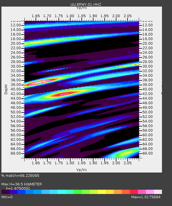
| Estimated Moho Depth: |
36.5 km |
| Estimated Crust Vp/Vs: |
1.68 |
| Assumed Crust Vp: |
6.207 km/s |
| Estimated Crust Vs: |
3.706 km/s |
| Estimated Crust Poisson's Ratio: |
0.22 |
|
| Radial Match: |
86.228065 % |
| Radial Bump: |
400 |
| Transverse Match: |
82.39755 % |
| Transverse Bump: |
400 |
| SOD ConfigId: |
22732711 |
| Insert Time: |
2020-09-20 01:43:00.028 +0000 |
| GWidth: |
2.5 |
| Max Bumps: |
400 |
| Tol: |
0.001 |
|

Signal To Noise
| Channel | StoN | STA | LTA |
| UU:BRWY:01:HHZ:20200906T01:28:32.520027Z | 6.2016106 | 4.830024E-8 | 7.788339E-9 |
| UU:BRWY:01:HHN:20200906T01:28:32.520027Z | 2.1967075 | 1.4425224E-8 | 6.566748E-9 |
| UU:BRWY:01:HHE:20200906T01:28:32.520027Z | 1.9017423 | 1.0164761E-8 | 5.3449725E-9 |
| Arrivals |
| Ps | 4.1 SECOND |
| PpPs | 15 SECOND |
| PsPs/PpSs | 19 SECOND |


