You are here: Home > Network List > WY - Yellowstone Wyoming Seismic Network Stations List
> Station YHH Holmes Hill, YNP, WY, USA > Earthquake Result Viewer
YHH Holmes Hill, YNP, WY, USA - Earthquake Result Viewer
| Earthquake location: |
Near Coast Of Central Chile |
| Earthquake latitude/longitude: |
-30.3/-71.6 |
| Earthquake time(UTC): |
2020/09/06 (250) 01:16:58 GMT |
| Earthquake Depth: |
31 km |
| Earthquake Magnitude: |
6.3 Mww |
| Earthquake Catalog/Contributor: |
NEIC PDE/us |
|
| Network: |
WY Yellowstone Wyoming Seismic Network |
| Station: |
YHH Holmes Hill, YNP, WY, USA |
| Lat/Lon: |
44.79 N/110.85 W |
| Elevation: |
2717 m |
|
| Distance: |
82.9 deg |
| Az: |
332.976 deg |
| Baz: |
146.519 deg |
| Ray Param: |
0.046533987 |
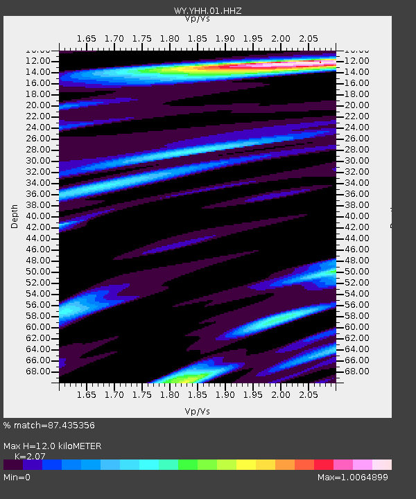
| Estimated Moho Depth: |
12.0 km |
| Estimated Crust Vp/Vs: |
2.07 |
| Assumed Crust Vp: |
6.35 km/s |
| Estimated Crust Vs: |
3.068 km/s |
| Estimated Crust Poisson's Ratio: |
0.35 |
|
| Radial Match: |
87.435356 % |
| Radial Bump: |
400 |
| Transverse Match: |
83.20073 % |
| Transverse Bump: |
400 |
| SOD ConfigId: |
22732711 |
| Insert Time: |
2020-09-20 01:46:34.937 +0000 |
| GWidth: |
2.5 |
| Max Bumps: |
400 |
| Tol: |
0.001 |
|
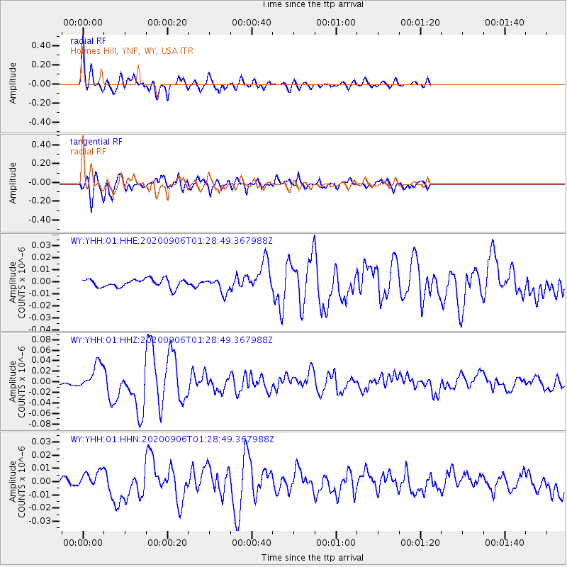
Signal To Noise
| Channel | StoN | STA | LTA |
| WY:YHH:01:HHZ:20200906T01:28:49.367988Z | 6.606433 | 2.5158784E-8 | 3.808225E-9 |
| WY:YHH:01:HHN:20200906T01:28:49.367988Z | 2.507621 | 6.5343118E-9 | 2.6057814E-9 |
| WY:YHH:01:HHE:20200906T01:28:49.367988Z | 1.828073 | 6.3087406E-9 | 3.4510332E-9 |
| Arrivals |
| Ps | 2.1 SECOND |
| PpPs | 5.7 SECOND |
| PsPs/PpSs | 7.7 SECOND |


