You are here: Home > Network List > TA - USArray Transportable Network (new EarthScope stations) Stations List
> Station D17K Noatak River, AK, USA > Earthquake Result Viewer
D17K Noatak River, AK, USA - Earthquake Result Viewer
| Earthquake location: |
Vanuatu Islands |
| Earthquake latitude/longitude: |
-17.1/167.6 |
| Earthquake time(UTC): |
2020/09/06 (250) 02:59:15 GMT |
| Earthquake Depth: |
8.2 km |
| Earthquake Magnitude: |
6.2 mww |
| Earthquake Catalog/Contributor: |
NEIC PDE/us |
|
| Network: |
TA USArray Transportable Network (new EarthScope stations) |
| Station: |
D17K Noatak River, AK, USA |
| Lat/Lon: |
67.70 N/163.08 W |
| Elevation: |
172 m |
|
| Distance: |
87.3 deg |
| Az: |
10.79 deg |
| Baz: |
207.967 deg |
| Ray Param: |
0.043429933 |
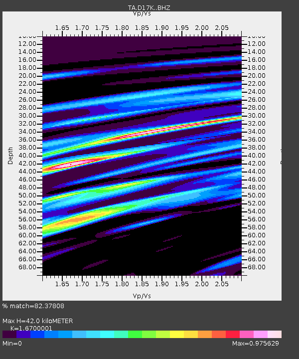
| Estimated Moho Depth: |
42.0 km |
| Estimated Crust Vp/Vs: |
1.67 |
| Assumed Crust Vp: |
6.276 km/s |
| Estimated Crust Vs: |
3.758 km/s |
| Estimated Crust Poisson's Ratio: |
0.22 |
|
| Radial Match: |
82.37808 % |
| Radial Bump: |
400 |
| Transverse Match: |
85.14798 % |
| Transverse Bump: |
400 |
| SOD ConfigId: |
22732711 |
| Insert Time: |
2020-09-20 03:11:29.063 +0000 |
| GWidth: |
2.5 |
| Max Bumps: |
400 |
| Tol: |
0.001 |
|

Signal To Noise
| Channel | StoN | STA | LTA |
| TA:D17K: :BHZ:20200906T03:11:31.124979Z | 2.697627 | 3.322969E-7 | 1.2318118E-7 |
| TA:D17K: :BHN:20200906T03:11:31.124979Z | 1.8410249 | 2.1576614E-7 | 1.1719892E-7 |
| TA:D17K: :BHE:20200906T03:11:31.124979Z | 1.0073655 | 1.2214805E-7 | 1.2125496E-7 |
| Arrivals |
| Ps | 4.6 SECOND |
| PpPs | 17 SECOND |
| PsPs/PpSs | 22 SECOND |


