You are here: Home > Network List > TA - USArray Transportable Network (new EarthScope stations) Stations List
> Station E18K Tukpahlearik Creek, AK, USA > Earthquake Result Viewer
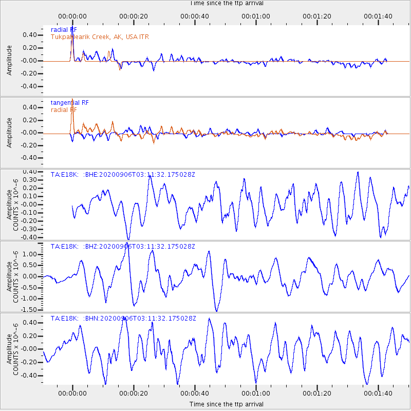
E18K Tukpahlearik Creek, AK, USA - Earthquake Result Viewer

| Earthquake location: |
Vanuatu Islands |
| Earthquake latitude/longitude: |
-17.1/167.6 |
| Earthquake time(UTC): |
2020/09/06 (250) 02:59:15 GMT |
| Earthquake Depth: |
8.2 km |
| Earthquake Magnitude: |
6.2 mww |
| Earthquake Catalog/Contributor: |
NEIC PDE/us |
|
| Network: |
TA USArray Transportable Network (new EarthScope stations) |
| Station: |
E18K Tukpahlearik Creek, AK, USA |
| Lat/Lon: |
67.42 N/160.60 W |
| Elevation: |
297 m |
|
| Distance: |
87.5 deg |
| Az: |
11.758 deg |
| Baz: |
210.302 deg |
| Ray Param: |
0.04327599 |
| Estimated Moho Depth: |
30.75 km |
| Estimated Crust Vp/Vs: |
1.72 |
| Assumed Crust Vp: |
6.276 km/s |
| Estimated Crust Vs: |
3.649 km/s |
| Estimated Crust Poisson's Ratio: |
0.24 |
|
| Radial Match: |
82.48545 % |
| Radial Bump: |
400 |
| Transverse Match: |
69.07214 % |
| Transverse Bump: |
400 |
| SOD ConfigId: |
22732711 |
| Insert Time: |
2020-09-20 03:11:36.667 +0000 |
| GWidth: |
2.5 |
| Max Bumps: |
400 |
| Tol: |
0.001 |
|
Signal To Noise
| Channel | StoN | STA | LTA |
| TA:E18K: :BHZ:20200906T03:11:32.175028Z | 4.456189 | 3.797484E-7 | 8.52182E-8 |
| TA:E18K: :BHN:20200906T03:11:32.175028Z | 2.2986646 | 2.2937621E-7 | 9.9786725E-8 |
| TA:E18K: :BHE:20200906T03:11:32.175028Z | 1.2672365 | 1.7333102E-7 | 1.3677874E-7 |
| Arrivals |
| Ps | 3.6 SECOND |
| PpPs | 13 SECOND |
| PsPs/PpSs | 17 SECOND |


