You are here: Home > Network List > TA - USArray Transportable Network (new EarthScope stations) Stations List
> Station F20K Avaraart Lake, AK, USA > Earthquake Result Viewer
F20K Avaraart Lake, AK, USA - Earthquake Result Viewer
| Earthquake location: |
Vanuatu Islands |
| Earthquake latitude/longitude: |
-17.1/167.6 |
| Earthquake time(UTC): |
2020/09/06 (250) 02:59:15 GMT |
| Earthquake Depth: |
8.2 km |
| Earthquake Magnitude: |
6.2 mww |
| Earthquake Catalog/Contributor: |
NEIC PDE/us |
|
| Network: |
TA USArray Transportable Network (new EarthScope stations) |
| Station: |
F20K Avaraart Lake, AK, USA |
| Lat/Lon: |
67.05 N/155.73 W |
| Elevation: |
136 m |
|
| Distance: |
88.2 deg |
| Az: |
13.56 deg |
| Baz: |
214.862 deg |
| Ray Param: |
0.04275404 |
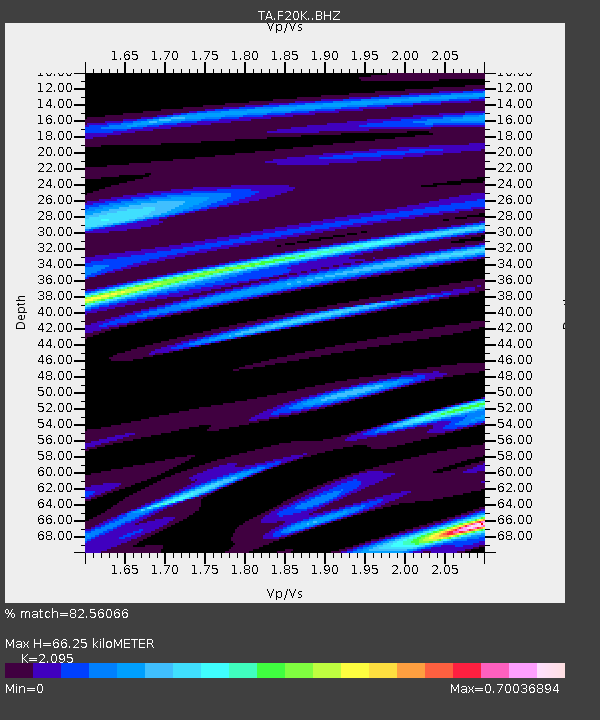
| Estimated Moho Depth: |
66.25 km |
| Estimated Crust Vp/Vs: |
2.10 |
| Assumed Crust Vp: |
6.522 km/s |
| Estimated Crust Vs: |
3.113 km/s |
| Estimated Crust Poisson's Ratio: |
0.35 |
|
| Radial Match: |
82.56066 % |
| Radial Bump: |
400 |
| Transverse Match: |
61.76824 % |
| Transverse Bump: |
400 |
| SOD ConfigId: |
22732711 |
| Insert Time: |
2020-09-20 03:11:49.859 +0000 |
| GWidth: |
2.5 |
| Max Bumps: |
400 |
| Tol: |
0.001 |
|
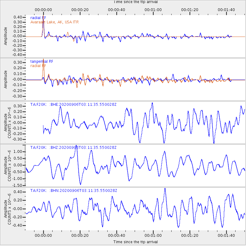
Signal To Noise
| Channel | StoN | STA | LTA |
| TA:F20K: :BHZ:20200906T03:11:35.550028Z | 2.2747428 | 5.451905E-7 | 2.3967127E-7 |
| TA:F20K: :BHN:20200906T03:11:35.550028Z | 1.3602213 | 1.1128977E-7 | 8.18174E-8 |
| TA:F20K: :BHE:20200906T03:11:35.550028Z | 0.8320441 | 8.768812E-8 | 1.0538879E-7 |
| Arrivals |
| Ps | 11 SECOND |
| PpPs | 31 SECOND |
| PsPs/PpSs | 42 SECOND |


