You are here: Home > Network List > TA - USArray Transportable Network (new EarthScope stations) Stations List
> Station H16K Elim, AK, USA > Earthquake Result Viewer
H16K Elim, AK, USA - Earthquake Result Viewer
| Earthquake location: |
Vanuatu Islands |
| Earthquake latitude/longitude: |
-17.1/167.6 |
| Earthquake time(UTC): |
2020/09/06 (250) 02:59:15 GMT |
| Earthquake Depth: |
8.2 km |
| Earthquake Magnitude: |
6.2 mww |
| Earthquake Catalog/Contributor: |
NEIC PDE/us |
|
| Network: |
TA USArray Transportable Network (new EarthScope stations) |
| Station: |
H16K Elim, AK, USA |
| Lat/Lon: |
64.64 N/162.24 W |
| Elevation: |
216 m |
|
| Distance: |
84.8 deg |
| Az: |
12.559 deg |
| Baz: |
208.862 deg |
| Ray Param: |
0.045266155 |
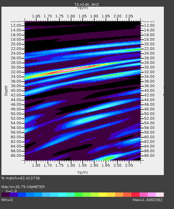
| Estimated Moho Depth: |
30.75 km |
| Estimated Crust Vp/Vs: |
1.80 |
| Assumed Crust Vp: |
6.276 km/s |
| Estimated Crust Vs: |
3.487 km/s |
| Estimated Crust Poisson's Ratio: |
0.28 |
|
| Radial Match: |
82.410736 % |
| Radial Bump: |
400 |
| Transverse Match: |
67.01022 % |
| Transverse Bump: |
400 |
| SOD ConfigId: |
22732711 |
| Insert Time: |
2020-09-20 03:12:07.010 +0000 |
| GWidth: |
2.5 |
| Max Bumps: |
400 |
| Tol: |
0.001 |
|
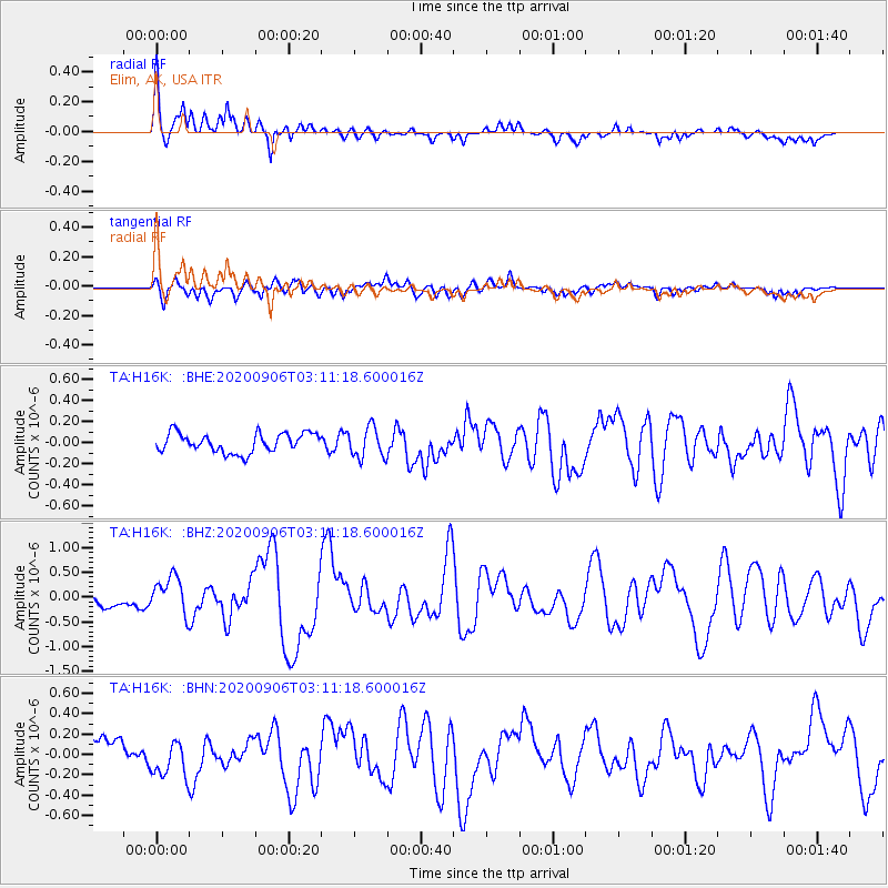
Signal To Noise
| Channel | StoN | STA | LTA |
| TA:H16K: :BHZ:20200906T03:11:18.600016Z | 2.499266 | 3.650014E-7 | 1.4604345E-7 |
| TA:H16K: :BHN:20200906T03:11:18.600016Z | 1.3432375 | 1.7905323E-7 | 1.3329975E-7 |
| TA:H16K: :BHE:20200906T03:11:18.600016Z | 1.5795062 | 1.4357308E-7 | 9.089745E-8 |
| Arrivals |
| Ps | 4.0 SECOND |
| PpPs | 13 SECOND |
| PsPs/PpSs | 17 SECOND |


