You are here: Home > Network List > TA - USArray Transportable Network (new EarthScope stations) Stations List
> Station R31K City Hall, Gustavus, AK, USA > Earthquake Result Viewer
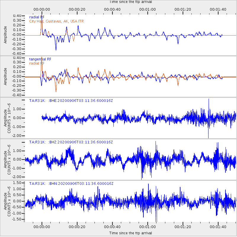
R31K City Hall, Gustavus, AK, USA - Earthquake Result Viewer
*The percent match for this event was below the threshold and hence no stack was calculated.
| Earthquake location: |
Vanuatu Islands |
| Earthquake latitude/longitude: |
-17.1/167.6 |
| Earthquake time(UTC): |
2020/09/06 (250) 02:59:15 GMT |
| Earthquake Depth: |
8.2 km |
| Earthquake Magnitude: |
6.2 mww |
| Earthquake Catalog/Contributor: |
NEIC PDE/us |
|
| Network: |
TA USArray Transportable Network (new EarthScope stations) |
| Station: |
R31K City Hall, Gustavus, AK, USA |
| Lat/Lon: |
58.41 N/135.74 W |
| Elevation: |
15 m |
|
| Distance: |
88.4 deg |
| Az: |
26.103 deg |
| Baz: |
233.057 deg |
| Ray Param: |
$rayparam |
*The percent match for this event was below the threshold and hence was not used in the summary stack. |
|
| Radial Match: |
76.26581 % |
| Radial Bump: |
400 |
| Transverse Match: |
63.697052 % |
| Transverse Bump: |
400 |
| SOD ConfigId: |
22732711 |
| Insert Time: |
2020-09-20 03:12:45.142 +0000 |
| GWidth: |
2.5 |
| Max Bumps: |
400 |
| Tol: |
0.001 |
|
Signal To Noise
| Channel | StoN | STA | LTA |
| TA:R31K: :BHZ:20200906T03:11:36.600016Z | 2.3554158 | 5.0392157E-7 | 2.1394166E-7 |
| TA:R31K: :BHN:20200906T03:11:36.600016Z | 1.3063432 | 2.873292E-7 | 2.1994924E-7 |
| TA:R31K: :BHE:20200906T03:11:36.600016Z | 1.1929739 | 2.6070785E-7 | 2.185361E-7 |
| Arrivals |
| Ps | |
| PpPs | |
| PsPs/PpSs | |


