You are here: Home > Network List > C0 - Colorado Geological Survey Seismic Network Stations List
> Station HAYD Hayden Colorado > Earthquake Result Viewer
HAYD Hayden Colorado - Earthquake Result Viewer
| Earthquake location: |
Central Mid-Atlantic Ridge |
| Earthquake latitude/longitude: |
7.7/-37.2 |
| Earthquake time(UTC): |
2020/09/06 (250) 06:51:19 GMT |
| Earthquake Depth: |
10 km |
| Earthquake Magnitude: |
6.7 Mww |
| Earthquake Catalog/Contributor: |
NEIC PDE/us |
|
| Network: |
C0 Colorado Geological Survey Seismic Network |
| Station: |
HAYD Hayden Colorado |
| Lat/Lon: |
40.53 N/107.27 W |
| Elevation: |
2202 m |
|
| Distance: |
69.9 deg |
| Az: |
310.269 deg |
| Baz: |
97.191 deg |
| Ray Param: |
0.055355914 |
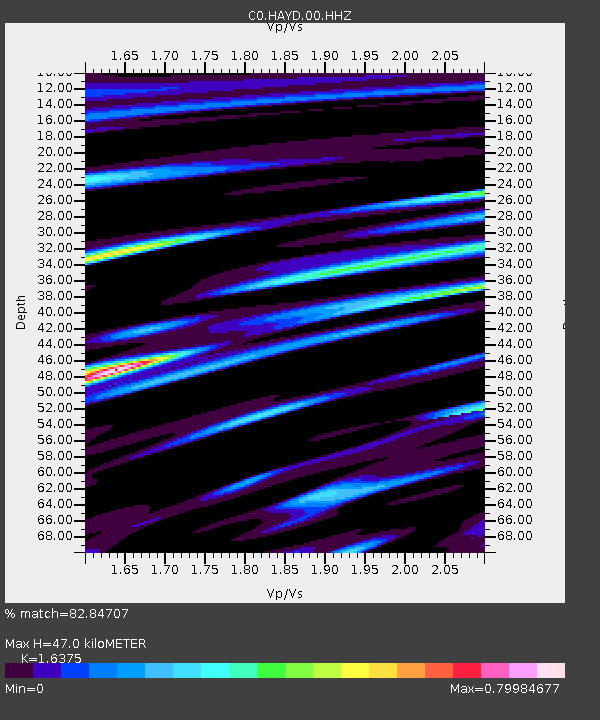
| Estimated Moho Depth: |
47.0 km |
| Estimated Crust Vp/Vs: |
1.64 |
| Assumed Crust Vp: |
6.159 km/s |
| Estimated Crust Vs: |
3.761 km/s |
| Estimated Crust Poisson's Ratio: |
0.20 |
|
| Radial Match: |
82.84707 % |
| Radial Bump: |
400 |
| Transverse Match: |
82.84707 % |
| Transverse Bump: |
400 |
| SOD ConfigId: |
22732711 |
| Insert Time: |
2020-09-20 06:58:19.445 +0000 |
| GWidth: |
2.5 |
| Max Bumps: |
400 |
| Tol: |
0.001 |
|

Signal To Noise
| Channel | StoN | STA | LTA |
| C0:HAYD:00:HHZ:20200906T07:01:58.748995Z | 4.5400724 | 3.047171E-7 | 6.711724E-8 |
| $trig.getChannelId() | $trig.getValue() | $trig.getSTA() | $trig.getLTA() |
| C0:HAYD:00:HHE:20200906T07:01:58.748995Z | 1.8057598 | 1.700903E-7 | 9.419321E-8 |
| Arrivals |
| Ps | 5.0 SECOND |
| PpPs | 19 SECOND |
| PsPs/PpSs | 24 SECOND |


