You are here: Home > Network List > CC - Cascade Chain Volcano Monitoring Stations List
> Station KWBU Kawak Butte > Earthquake Result Viewer
KWBU Kawak Butte - Earthquake Result Viewer
| Earthquake location: |
Central Mid-Atlantic Ridge |
| Earthquake latitude/longitude: |
7.7/-37.2 |
| Earthquake time(UTC): |
2020/09/06 (250) 06:51:19 GMT |
| Earthquake Depth: |
10 km |
| Earthquake Magnitude: |
6.7 Mww |
| Earthquake Catalog/Contributor: |
NEIC PDE/us |
|
| Network: |
CC Cascade Chain Volcano Monitoring |
| Station: |
KWBU Kawak Butte |
| Lat/Lon: |
43.75 N/121.31 W |
| Elevation: |
1783 m |
|
| Distance: |
80.5 deg |
| Az: |
313.039 deg |
| Baz: |
88.484 deg |
| Ray Param: |
0.04825518 |
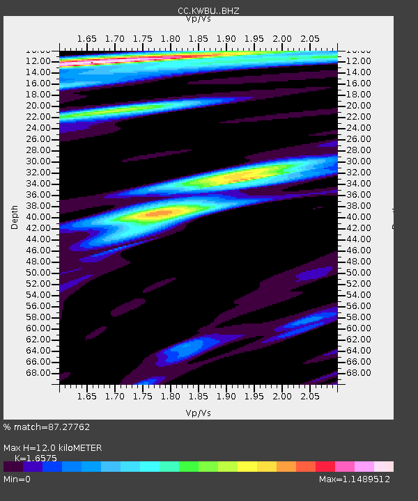
| Estimated Moho Depth: |
12.0 km |
| Estimated Crust Vp/Vs: |
1.66 |
| Assumed Crust Vp: |
6.597 km/s |
| Estimated Crust Vs: |
3.98 km/s |
| Estimated Crust Poisson's Ratio: |
0.21 |
|
| Radial Match: |
87.27762 % |
| Radial Bump: |
400 |
| Transverse Match: |
86.70407 % |
| Transverse Bump: |
400 |
| SOD ConfigId: |
22732711 |
| Insert Time: |
2020-09-20 07:00:16.987 +0000 |
| GWidth: |
2.5 |
| Max Bumps: |
400 |
| Tol: |
0.001 |
|

Signal To Noise
| Channel | StoN | STA | LTA |
| CC:KWBU: :BHZ:20200906T07:02:59.550021Z | 3.884855 | 3.7887992E-7 | 9.752742E-8 |
| CC:KWBU: :BHN:20200906T07:02:59.550021Z | 0.9719977 | 1.6803149E-7 | 1.7287232E-7 |
| CC:KWBU: :BHE:20200906T07:02:59.550021Z | 0.8210184 | 2.4585006E-7 | 2.9944525E-7 |
| Arrivals |
| Ps | 1.2 SECOND |
| PpPs | 4.7 SECOND |
| PsPs/PpSs | 5.9 SECOND |


